Morrinho de Açúcar
| Morrinho de Açúcar | |
|---|---|
|
Morrinho de Açúcar | |
| Highest point | |
| Elevation | 405.3 m (1,330 ft) [1] |
| Listing | List of mountains in Cape Verde |
| Coordinates | 16°43′12″N 22°57′45″W / 16.72000°N 22.96250°WCoordinates: 16°43′12″N 22°57′45″W / 16.72000°N 22.96250°W [1] |
| Geography | |
 northern Sal | |
| Geology | |
| Mountain type | Formation |
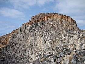
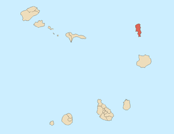
Morrinho de Açúcar'' (Portuguese meaning "sugar formation”), is a small hill iin the northern part of the island of Sal in Cape Verde. It is situated 15 km north of the island capital Espargos.
Kapverdische Inseln, Dumont Reisetaschenbuch, p. 3. Oplaag, 2007, ISBN 978-3-7701-5968-0</ref>. It is also a protected landscape because of its geological value.[2]
It is connected with a track with Espargos and Terra Boa to the south. Northeast is the island's northeasternmost point, Ponta Preta do Norte or Reguinho Fiura. The surrounding area consists a plain but southwest consists of mountains.
See also
References
Bibliography
- Ricardo A. S. Ramalho, Building the Cape Verde Islands, Springer, 2011, p. 101
This article is issued from Wikipedia - version of the 12/3/2016. The text is available under the Creative Commons Attribution/Share Alike but additional terms may apply for the media files.

