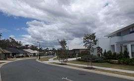
Wakerley, Queensland
| Wakerley Brisbane, Queensland | |||||||||||||
|---|---|---|---|---|---|---|---|---|---|---|---|---|---|
 Watervale Parade, 2014 | |||||||||||||
| Population | 7,804 (2011 census)[1] | ||||||||||||
| Postcode(s) | 4154 | ||||||||||||
| Location | 15 km (9 mi) from Brisbane GPO | ||||||||||||
| LGA(s) | City of Brisbane | ||||||||||||
| State electorate(s) | Electoral district of Chatsworth | ||||||||||||
| Federal Division(s) | Division of Bonner | ||||||||||||
| |||||||||||||
Wakerley is a modern mid-ring suburb of Brisbane, Australia. It is 15 kilometres (9.3 mi) east of the CBD, and close to the bayside, airport and city.
Wakerley was named after early settler J W Wakerley.
Demographics

In the 2011 census, the population of Wakerley was 7,804, 50.9% female and 49.1% male.[1] The median age of the Wakerley population was 33 years, 4 years below the Australian median. 68.7% of people living in Wakerley were born in Australia, compared to the national average of 69.8%; the next most common countries of birth were England 6.5%, New Zealand 6.3%, South Africa 4%, Scotland 1%, India 0.6%. 85.8% of people spoke only English at home; the next most common languages were 1.8% Afrikaans, 0.9% Greek, 0.7% Spanish, 0.6% Hindi, 0.6% Italian.[1]
References
- 1 2 3 Australian Bureau of Statistics (31 October 2012). "Wakerley, Qld (State Suburb)". 2011 Census QuickStats. Retrieved 24 October 2013.
External links
Coordinates: 27°29′S 153°10′E / 27.483°S 153.167°E