Negreet, Louisiana
| Negreet | |
| Unincorporated community | |
| Country | United States |
|---|---|
| State | Louisiana |
| Parish | Sabine |
| Coordinates | 31°28′10″N 93°34′30″W / 31.46944°N 93.57500°WCoordinates: 31°28′10″N 93°34′30″W / 31.46944°N 93.57500°W |
|
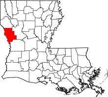
Location of Negreet in Louisiana | |
 Location of Louisiana in the United States | |
Negreet is an unincorporated community in Sabine Parish, Louisiana, United States. It is located near the intersection of Louisiana Highway 191 and Louisiana Highway 476, just east of the Toledo Bend Reservoir.
History
Negreet was founded in 1822 and families began settling in sizeable numbers as the completion of nearby Fort Jesup brought the once lawless "Neutral Strip" under control.[1]
The community flourished with farms and plantations until the Civil War, which devastated the area and displaced many of its residents.[2]
In January 2014, the ACLU filed suit against the Sabine Parish School Board, Superintendent Sara Erarb, Principal Gene Wright and teacher Rita Roark of Negreet High School, alleging officials at one of its schools harassed a sixth-grader because of his Buddhist faith and that the district routinely pushes Christian beliefs upon their students.[3][4][5][6] In March 2014, the U.S. District Court ruled against the school board.[7][8]
Climate
This climatic region is typified by large seasonal temperature differences, with warm to hot (and often humid) summers and cold (sometimes severely cold) winters. According to the Köppen Climate Classification system, Negreet has a humid subtropical climate, abbreviated "Cfa" on climate maps.[9]
Education
Public schools in Sabine Parish are operated by the Sabine Parish School Board. The community of Negreet is zoned to Negreet High School (Grades PK-12).
Notable people
- Cliff Ammons, former member of the Louisiana House of Representatives and the "father of Toledo Bend Reservoir, was born in Negreet in 1918.[10]
References
- ↑ Negreet - Sabine Parish Tourist Commission.
- ↑ Negreet - Toledo-Bend.com
- ↑ Lane v. Sabine Parish School Board; ACLU; January 22, 2014.
- ↑ Lane v. Sabine Parish School Board Complaint; ACLU; January 22, 2014.
- ↑ ACLU Accuses La. School of Religious Harassment; ABC News; January 23, 2014.
- ↑ Louisiana School Accused Of Religious Harassment By ACLU; Huffington Post; January 22, 2014.
- ↑ Louisiana School Agrees to Court Order Ending Discriminatory Religious Practices; ACLU; March 14, 2014.
- ↑ Consent Decree and Order; U.S. District Court; March 14, 2014.
- ↑ Climate Summary for Negreet, Louisiana
- ↑ "Clifton R. "Cliff" Ammons". findagrave.com. Retrieved December 24, 2010.
External links
- Sabine Parish
- Sabine Parish School District
- U.S. Geological Survey Geographic Names Information System: Negreet
