National road 5 (Poland)
| ||||
|---|---|---|---|---|
| Droga krajowa nr 5 | ||||
|
| ||||
| Route information | ||||
|
| ||||
| Maintained by GDDKiA | ||||
| Length: | 496 km (308 mi) | |||
| Major junctions | ||||
| From: | Nowe Marzy | |||
| To: | Lubawka (PL-CZ border) | |||
| Location | ||||
| Regions: |
Kuyavian-Pomeranian Voivodeship Greater Poland Voivodeship Lower Silesian Voivodeship | |||
| Major cities: | Jelenia Góra, Wrocław, Leszno, Poznań, Bydgoszcz | |||
| Highway system | ||||
| ||||
National road 5 in Lubawka
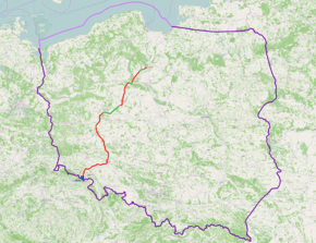
National road 5 (Polish: Droga krajowa nr 5) is a route belonging to the Polish national road network. The highway connects some of the biggest urban agglomerations in Poland, i.e. Trójmiasto, Bydgoszcz, Poznań and Wrocław. It runs from Nowe Marzy to Lubawka at the Czech border and between Bielany Wrocławskie and Kostomłoty merges with A4 motorway. On the segment from Nowe Marzy to Wrocław, it is a component of European route E261.
Major cities and towns along the route
- Nowe Marzy (road A1, 91)
- Świecie (road 91)
- Bydgoszcz (road 10, 25, 80)
- Szubin
- Żnin
- Gniezno (road 15)
- Pobiedziska
- Poznań (road A2, 11, 92)
- Stęszew (road 32)
- Kościan
- Śmigiel
- Leszno (road 12)
- Rydzyna
- Bojanowo
- Rawicz (road 36)
- Żmigród
- Trzebnica (road 15)
- Wrocław (road A8, 94, 98)
- Bielany Wrocławskie (road A4, 98)
- Kąty Wrocławskie
- Strzegom
- Bolków (road 3)
- Kamienna Góra
- Lubawka, border with Czech Republic
| Wikimedia Commons has media related to National road 5 (Poland). |
Coordinates: 52°10′40″N 16°42′38″E / 52.177854°N 16.710525°E
This article is issued from Wikipedia - version of the 12/22/2014. The text is available under the Creative Commons Attribution/Share Alike but additional terms may apply for the media files.

