National Register of Historic Places listings in Ness County, Kansas

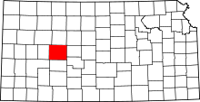
Location of Ness County in Kansas
This is a list of the National Register of Historic Places listings in Ness County, Kansas. It is intended to be a complete list of the properties and districts on the National Register of Historic Places in Ness County, Kansas, United States. The locations of National Register properties and districts for which the latitude and longitude coordinates are included below, may be seen in an online map.
There are 7 properties and districts listed on the National Register in the county.
- This National Park Service list is complete through NPS recent listings posted December 16, 2016.[1]
Current listings
| [2] | Name on the Register[3] | Image | Date listed[4] | Location | City or town | Description |
|---|---|---|---|---|---|---|
| 1 | George Washington Carver Homestead Site | |
(#77000593) |
1.5 miles (2.4 km) south of Beeler 38°25′44″N 100°11′28″W / 38.428882°N 100.191165°W |
Beeler | |
| 2 | Indian Village on Pawnee Fork | Upload image | (#07000609) |
Address Restricted |
Bazine vicinity | |
| 3 | Lion Block | |
(#08000986) |
216 West Main St. 38°27′15″N 99°54′26″W / 38.454136°N 99.907304°W |
Ness City | |
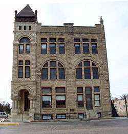
| 4 | Ness County Bank |  |
(#72000519) |
Main St. and Pennsylvania Ave. 38°27′15″N 99°54′19″W / 38.454167°N 99.905278°W |
Ness City | |
| 5 | Pawnee River Tributary Bridge | |
(#85001446) |
8 miles south of Bazine 38°19′21″N 99°41′43″W / 38.322444°N 99.695366°W |
Bazine | |
| 6 | Thornburg Barn | |
(#09000192) |
Ness-Gove county line, 0.5 miles (0.8 km) west of D Road[5] 38°41′45″N 100°10′55″W / 38.695925°N 100.181902°W |
Utica | Agriculture-Related Resources of Kansas MPS |
| 7 | Henry Tilley House | |
(#06001053) |
108 W. 2nd St. 38°38′13″N 99°55′57″W / 38.637045°N 99.93255°W |
Ransom |
See also
- List of National Historic Landmarks in Kansas
- National Register of Historic Places listings in Kansas
References
- ↑ "National Register of Historic Places: Weekly List Actions". National Park Service, United States Department of the Interior. Retrieved on December 16, 2016.
- ↑ Numbers represent an ordering by significant words. Various colorings, defined here, differentiate National Historic Landmarks and historic districts from other NRHP buildings, structures, sites or objects.
- ↑ National Park Service (2010-07-09). "National Register Information System". National Register of Historic Places. National Park Service.
- ↑ The eight-digit number below each date is the number assigned to each location in the National Register Information System database, which can be viewed by clicking the number.
- ↑ "National Register of Historic Places Registration Form: Thornburg Barn". Kansas Historical Society. Retrieved 2015-04-01.
External links
| Wikimedia Commons has media related to National Register of Historic Places in Ness County, Kansas. |
This article is issued from Wikipedia - version of the 4/6/2016. The text is available under the Creative Commons Attribution/Share Alike but additional terms may apply for the media files.

