Malheur National Forest
| Malheur National Forest | |
|---|---|
|
IUCN category VI (protected area with sustainable use of natural resources) | |
|
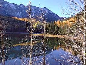
Strawberry Lake in the Malheur National Forest | |
 | |
| Location | Oregon, USA |
| Nearest city | Canyon City, Oregon |
| Coordinates | 44°17′00″N 118°47′04″W / 44.2832129°N 118.7843893°WCoordinates: 44°17′00″N 118°47′04″W / 44.2832129°N 118.7843893°W[1] |
| Area | 1,465,287 acres (5,930 km2)[2] |
| Established | July 1, 1908[3] |
| Visitors | 242,000 (in 2006)[4] |
| Governing body | U.S. Forest Service |
| Website | Malheur National Forest |
The Malheur National Forest is a National Forest in the U.S. state of Oregon. It contains more than 1.4 million acres (5,700 km2) in the Blue Mountains of eastern Oregon. The forest consists of high desert grasslands, sage, juniper, pine, fir, and other tree species. Elevations vary from about 4,000 feet (1,200 m) to the 9,038-foot (2,755 m) peak of Strawberry Mountain. The Strawberry Mountains extend east to west through the center of the forest. U.S. Route 395 runs south to north through the forest, while U.S. Route 26 runs east to west.
Overview

The forest was established by President Theodore Roosevelt on June 13, 1908, and is named after the Malheur River, from the French, meaning "misfortune". It is managed by the United States Forest Service for timber extraction, cattle grazing, gold mining and wilderness use. A 1993 Forest Service study estimated that the extent of old growth in the forest was 312,000 acres (1,260 km2).[5]
In descending order of land area, the forest is located in parts of Grant, Harney, Baker, and Malheur counties.[6] There are three ranger districts in the forest, with offices in John Day, Prairie City, and Hines.
The Malheur National Forest contains the largest known organism (by area) in the world: an Armillaria solidipes that spans 2,200 acres (8.9 km2).[7]
Wilderness
There are two wilderness areas in the Malheur National Forest.
- Strawberry Mountain Wilderness at 68,700 acres (278 km2)
- Monument Rock Wilderness at 19,620 acres (79 km2), located partially within the Wallowa–Whitman National Forest
See also
- Vinegar Hill-Indian Rock Scenic Area, a high-elevation scenic area in the northeast portion of the forest
- Malheur National Wildlife Refuge, a federally protected refuge to the south of the forest
References
- ↑ "Malheur National Forest". Geographic Names Information System. United States Geological Survey. Retrieved April 11, 2009.
- ↑ "Land Areas of the National Forest System" (PDF). U.S. Forest Service. January 2012. Retrieved June 30, 2012.
- ↑ "The National Forests of the United States" (PDF). ForestHistory.org. Retrieved July 30, 2012.
- ↑ "Revised Visitation Estimates" (PDF). National Forest Service.
- ↑ Bolsinger, Charles L.; Waddell, Karen L. (1993). "Area of old-growth forests in California, Oregon, and Washington" (PDF). Resource Bulletin PNW-RB-197. United States Forest Service, Pacific Northwest Research Station.
- ↑ Desolation Butte quadrangle, Oregon : 7.5-minute series. U.S. Forest Service.
- ↑ Beale, Bob. April 10, 2003. Humungous fungus: world's largest organism? at Environment & Nature News, ABC Online. Accessed June 25, 2008.
External links
| Wikimedia Commons has media related to Malheur National Forest. |
