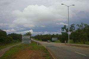
Knuckey Lagoon, Northern Territory
| Knuckey Lagoon Darwin, Northern Territory | |||||||||||||
|---|---|---|---|---|---|---|---|---|---|---|---|---|---|
 | |||||||||||||
| Population | 66 (2006)[1] | ||||||||||||
| Established | 1869 | ||||||||||||
| Postcode(s) | 0828 | ||||||||||||
| Location |
| ||||||||||||
| LGA(s) | Litchfield Municipality | ||||||||||||
| Territory electorate(s) | Nelson | ||||||||||||
| Federal Division(s) | Solomon | ||||||||||||
| |||||||||||||
Knuckey Lagoon is an outer suburban area in Darwin. It is 18 km East of the Darwin CBD. Its Local Government Area is the Litchfield Municipality. The suburb is mostly a rural area, on the fringe of Metropolitan Darwin. The area was named by Surveyor General G W Goyder after his Senior Surveyor, Cornishman, Richard Randall Knuckey. [2]

Knuckey Lagoon
References
- ↑ Australian Bureau of Statistics (25 October 2007). "Knuckey Lagoon (State Suburb)". 2006 Census QuickStats. Retrieved 2008-03-01.
- ↑ "The Origin of Suburbs, Localities, Towns and Hundreds in the Greater Darwin area". Northern Territory Government. Retrieved 9 May 2014.
External links
Coordinates: 12°25′33″S 130°56′32″E / 12.42583°S 130.94222°E
This article is issued from Wikipedia - version of the 5/9/2014. The text is available under the Creative Commons Attribution/Share Alike but additional terms may apply for the media files.