Knowle, Bristol
| Knowle | |
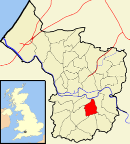
 Boundaries of the city council ward. |
|
| Population | 11,315 (2011.Ward)[1] |
|---|---|
| OS grid reference | ST603707 |
| Unitary authority | Bristol |
| Ceremonial county | Bristol |
| Region | South West |
| Country | England |
| Sovereign state | United Kingdom |
| Post town | BRISTOL |
| Postcode district | BS4 |
| Dialling code | 0117 |
| Police | Avon and Somerset |
| Fire | Avon |
| Ambulance | South Western |
| EU Parliament | South West England |
| UK Parliament | Bristol South |
Coordinates: 51°26′02″N 2°34′20″W / 51.4340°N 2.5721°W

Knowle is a district and council ward in the south east of the city of Bristol in England, United Kingdom. It is bordered by Filwood Park to the west, Brislington to the east, Whitchurch and Hengrove to the south and Totterdown to the north.
Broadwalk shopping centre provides the majority of the shopping facilities. The Wells Road runs through Knowle from Totterdown to Whitchurch. Broadwalk is a tree lined boulevard that heads westwards towards Filwood.
Redcatch Park is the main green space with football pitches, children's play area, a MUGA (Multi Games Area), tennis courts and a croquet club. This is supported by The Friends of Redcatch Park, a group of local residents who help Bristol City Council enhance and protect the space and who organise events in the park. The library is within Broadwalk shopping centre.
Community groups operate in and around the Knowle area. Redcatch Community Association run the Redcatch Centre in Redcatch Road, on the boundary of Redcatch Park – a resource for community groups and private and public events. Clubs and groups include the Knowle and Totterdown Local History Group, Redcatch Rollers (Short Mat Bowling), Redcatch Tea Dance, and Redcatch Art Club who all meet at Redcatch Community Centre. Knowle Community Association run a community centre in The Square, Knowle Park, with activities including Knowle East Youth Club. Other organisations are Broad Walk Neighbourhood Watch, which acts as a portal for the local community of Knowle and those in and around Broad Walk, and the St John Ambulance Knowle & Totterdown Division (www.sja.org.uk/kt).
There are good views of the city just above Perrett's Park, along Sylvia Avenue which is lined by Victorian terraces.
See also
References
External links
| Wikimedia Commons has media related to Knowle (Bristol ward). |