Cranstackie
| Cranstackie | |
|---|---|
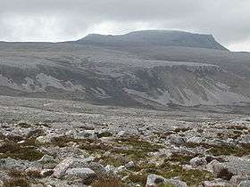
 Cranstackie from the east. | |
| Highest point | |
| Elevation | 801 m (2,628 ft) |
| Listing | Corbett, Marilyn |
| Geography | |
| Location | Assynt, Scotland |
| OS grid | NC350556 |
| Topo map | OS Landranger 9 |
Cranstackie is a mountain of 801 m in Sutherland, the northwestern tip of the Scottish Highlands. It is a Corbett located west of Loch Eriboll and northeast of Foinaven. Like Foinaven and Beinn Spionnaidh to the northeast, its top is covered with loose, broken quartzite. The slope is much steeper on the west side than the east, but neither approach is easy due to the covering of loose rock.
Coordinates: 58°27′27″N 4°49′47″W / 58.45738°N 4.82973°W
This article is issued from Wikipedia - version of the 3/16/2013. The text is available under the Creative Commons Attribution/Share Alike but additional terms may apply for the media files.