Blacklick Estates, Ohio
| Blacklick Estates, Ohio | |
|---|---|
| Census-designated place | |
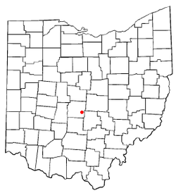
 Location of Blacklick Estates, Ohio | |
| Coordinates: 39°54′25″N 82°51′47″W / 39.90694°N 82.86306°WCoordinates: 39°54′25″N 82°51′47″W / 39.90694°N 82.86306°W | |
| Country | United States |
| State | Ohio |
| County | Franklin |
| Townships | Madison, Truro |
| Area | |
| • Total | 1.92 sq mi (4.96 km2) |
| • Land | 1.89 sq mi (4.90 km2) |
| • Water | 0.02 sq mi (0.06 km2) |
| Elevation[1] | 751 ft (229 m) |
| Population (2010) | |
| • Total | 8,682 |
| • Density | 4,592/sq mi (1,773.1/km2) |
| Time zone | Eastern (EST) (UTC-5) |
| • Summer (DST) | EDT (UTC-4) |
| FIPS code | 39-06670[2] |
| GNIS feature ID | 1867447[1] |
Blacklick Estates is a census-designated place (CDP) in Franklin County, Ohio, United States: partly in Madison Township and partly in Truro Township. As of the 2010 census the population was 8,682,[3] down from 9,518 at the 2000 census.
Geography
Blacklick Estates is located in southeastern Franklin County at 39°54′25″N 82°51′47″W / 39.90694°N 82.86306°W (39.907034, -82.863025).[4] It is bordered to the north, east, and south by the city of Columbus, and to the west by unincorporated land in Madison Township. Ohio State Route 317 (S. Hamilton Road) forms the western edge of the CDP. Downtown Columbus is 10 miles (16 km) to the northwest.
According to the United States Census Bureau, the CDP has a total area of 1.92 square miles (4.96 km2), of which 0.023 square miles (0.06 km2), or 1.25%, is water.[3]
Demographics
| Historical population | |||
|---|---|---|---|
| Census | Pop. | %± | |
| 1970 | 8,351 | — | |
| 1980 | 11,223 | 34.4% | |
| 1990 | 10,080 | −10.2% | |
| 2000 | 9,518 | −5.6% | |
| 2010 | 8,682 | −8.8% | |
| source:[5] | |||
As of the census[2] of 2000, there were 9,518 people, 3,317 households, and 2,567 families residing in the CDP. The population density was 4,775.3 people per square mile (1,846.7/km²). There were 3,449 housing units at an average density of 1,730.4/sq mi (669.2/km²). The racial makeup of the CDP was 86.72% White, 8.97% Black or African American, 0.38% Native American, 1.07% Asian, 0.11% Pacific Islander, 0.56% from other races, and 2.20% from two or more races. Hispanic or Latino of any race were 1.26% of the population.
There were 3,317 household, out of which 38.5% had children under the age of 18 living with them, 59.0% were married couples living together, 13.5% had a female householder with no husband present, and 22.6% were non-families. 16.8% of all households were made up of individuals and 3.6% had someone living alone who was 65 years of age or older. The average household size was 2.87 and the average family size was 3.22.
In the CDP the population was spread out with 29.3% under the age of 18, 8.8% from 18 to 24, 32.5% from 25 to 44, 22.6% from 45 to 64, and 6.8% who were 65 years of age or older. The median age was 33 years. For every 100 females there were 95.8 males. For every 100 females age 18 and over, there were 95.0 males.
The median income for a household in the CDP was $47,277, and the median income for a family was $51,766. Males had a median income of $35,427 versus $26,805 for females. The per capita income is $18,385. About 4.0% of families and 5.5% of the population were below the poverty line, including 4.2% of those under age 18 and 11.2% of those age 65 or over.
In 2007, Blacklick Estates was listed as the second most affordable place to live in the U.S. by Money on CNNMoney.com.[6]
History
Three hundred homes in Blacklick Estates were flooded on September 14, 1979, when Blacklick Creek topped a levee due to heavy rains from Hurricane Frederic.[7]
References
- 1 2 "US Board on Geographic Names". United States Geological Survey. 2007-10-25. Retrieved 2008-01-31.
- 1 2 "American FactFinder". United States Census Bureau. Archived from the original on 2013-09-11. Retrieved 2008-01-31.
- 1 2 "Geographic Identifiers: 2010 Census Summary File 1 (G001), Blacklick Estates CDP, Ohio". American FactFinder. U.S. Census Bureau. Retrieved July 1, 2016.
- ↑ "US Gazetteer files: 2010, 2000, and 1990". United States Census Bureau. 2011-02-12. Retrieved 2011-04-23.
- ↑ "CENSUS OF POPULATION AND HOUSING (1790-2000)". U.S. Census Bureau. Retrieved 2010-07-17.
- ↑ Cox, Jeff (July 16, 2007), Most-Affordable-Towns, CNNMoney.com, via Yahoo! Finance, retrieved December 9, 2010.
- ↑ Schmidlin, Thomas W.; Schmidlin, Jeanne Appelhans (1996), Thunder in the Heartland: A Chronicle of Outstanding Weather Events in Ohio, Kent State University Press, p. 219, ISBN 978-0-87338-549-7.
