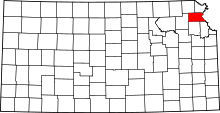
Benton Township, Atchison County, Kansas
| Benton Township | |
|---|---|
| Township | |
 Location in Atchison County | |
| Coordinates: 39°28′05″N 095°24′41″W / 39.46806°N 95.41139°WCoordinates: 39°28′05″N 095°24′41″W / 39.46806°N 95.41139°W | |
| Country | United States |
| State | Kansas |
| County | Atchison |
| Area | |
| • Total | 60.3 sq mi (156.3 km2) |
| • Land | 60.2 sq mi (155.9 km2) |
| • Water | 0.2 sq mi (0.4 km2) 0.26% |
| Elevation | 1,109 ft (338 m) |
| Population (2010) | |
| • Total | 1,014 |
| • Density | 17/sq mi (6.5/km2) |
| GNIS feature ID | 0473478 |
Benton Township is a township in Atchison County, Kansas, United States. As of the 2010 census, its population was 1,014.[1]
Geography
Benton Township covers an area of 60.3 square miles (156.3 km2) and contains one incorporated settlement, Effingham. According to the USGS, it contains four cemeteries: Maple Grove, Monrovia, Neill and Pleasant Grove.
The stream of North Fork Stranger Creek runs through this township.
References
- ↑ "Geographic Identifiers: 2010 Demographic Profile Data (G001): Benton township, Atchison County, Kansas". U.S. Census Bureau, American Factfinder. Retrieved May 13, 2013.
External links
This article is issued from Wikipedia - version of the 10/31/2016. The text is available under the Creative Commons Attribution/Share Alike but additional terms may apply for the media files.
