Ardara, County Donegal
| Ardara Ard an Rátha | |
|---|---|
| Town | |
|
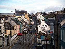
Front Street, Ardara | |
 Ardara Location in Ireland | |
| Coordinates: 54°46′00″N 8°24′00″W / 54.766667°N 8.4°WCoordinates: 54°46′00″N 8°24′00″W / 54.766667°N 8.4°W | |
| Country | Ireland |
| Province | Ulster |
| County | County Donegal |
| Government | |
| • Dáil Éireann | Donegal South-West |
| Elevation[1] | 45 m (148 ft) |
| Population (2011) | |
| • Urban | 731 |
| Time zone | WET (UTC+0) |
| • Summer (DST) | IST (WEST) (UTC-1) |
| Irish Grid Reference | G731906 |
| Website |
www |


Ardara (Irish: Ard an Rátha, meaning "Height of the Fort"), pronounced "Ardra", is a small town in County Donegal, Ireland. It is located on the N56 and R261 roads. The community has a population of 731 (per the 2011 Census). Over recent years the town has seen some great growth with a lot of the pubs and shops being renovated. Some of the main scenic points near the town are the Glengesh Pass, the Maghera Falls and the views out over the Atlantic from Loughros Point.
Culture
Ardara, one of the five designated heritage towns in Donegal, is situated in the beautiful south west region of Donegal. Close by is the Owenea River, where the salmon and trout fishing is widely regarded as one of the best in the country. Just outside the town is the spectacular Glengesh Pass. The Owentocker river runs through the town. The town boasts top class blue flag beaches and a first rate links golf course, all close by.
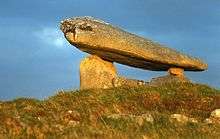
The name Ard a’ Ratha which means ‘Height of the fort’ comes from the earthen ring-fort, which crowns the hill to the northeast of the town. Christianity was introduced to Ardara in the 6th century by St. Conall Caol who was a direct descendant of St. Colmcille. All the information on the Festivals of Ardara is available on the town website.[2] The town is known for it's festivals throughout the year some of the most popular being the "Cup of Tae" Festival, a traditional music festival, each May and a multicultural festival called 'The Melting Pot' festival is held on the bank holiday weekend in June, featuring music, dance and art from across the world. Ardara is a vibrant and bustling town which is very popular with holiday makers. Ardara has been long associated with the tweed and knitwear industries. From the 1870s this trade became a cottage industry with home spun and hand dyed woollen and tweed items being created. The Ardara Heritage Centre, formally the town Courthouse, profiles the development of the tweed industry. To this day several shops in the town still sell high quality tweed and knitwear. Ardara is situated close to the small River Owentocker. The pubs of Ardara are welcoming and friendly: Teague's Bar, The Beehive Bar, The Hill's Bar, The Corner House, Nancy's Bar, Doherty's Bar, The Ceili House Bar, The Nesbitt Arms Hotel & Woodhill House – the visitor can experience a rich mix of traditional music. The Owenea River just out of town provides unparalleled salmon and trout fishing and is widely regarded as one of the best in the country. Ardara and its hinterland has a rich built and cultural heritage. There are a number of archaeological monuments of note in the area which date from prehistoric times. These are the Neolithic (c.4,000 BC to 2,500 BC) portal tombs (dolmens) at Kilclooney, Lackaweer and Lackaghtermon, and the court tomb at Kilclooney. Evidence of Bronze Age (2,500 BC to 600 BC) activity in the region consists of the standing stones at the Owenea Bridge, sometimes known as Finn MacCool's shoulder stone, and those at Mullivea, Lough Fad and Kinnoghty. There are a series of earthen ringforts dating to the early historic period (c.500 AD to 1,000 AD), the most notable of these is the ringfort from which Ardara got its name: Ard an Ratha (‘height of the fort’).
Ardara boasts a number of established Irish Clan names, and historically the area was home to the O’Breslin (Breslin) clan and the O’Boyle (Boyle) clan. The history of their existence can clearly be seen dotted throughout the landscape both physically (Doon Fort, the Ring Fort atop the hill overlooking Ardara) and in the placenames e.g. Cashel, or O’Boyle's island (on Kiltoorish Lough).
Other strong family names persist and reflect the nomadic nature of early Irish life. Family names such McHugh, Gallagher, McNelis, McGill, O’Donnell abound and give some notion of the alliances that permeated the clan structure in early Gaelic Ireland.
There are many sources of data around the beginning of the 20th Century and the Census of 1901 and 1911 are a fine example (although be warned, the spelling of family surnames is often wrong as the Census note takers had difficulty spelling the Gaelic names). Therefore, you will see Manelis representing McNelis, Mulloy instead of Molloy, McGill as McGlll etc.
Notable people
- Anthony Molloy, captained Donegal in their first ever All-Ireland Senior Football Championship title-winning season in 1992
- Pat Shovlin, Donegal goalkeeping coach in their second ever All-Ireland Senior Football Championship title-winning season in 2012
- John Doherty (musician)
- Bibi Baskin (Television personality)
- Charlie Bennett (Councillor)
- John Molloy ( Tweed and Knitwear Manufacturer)
Donegal County Directory for 1862
The Donegal County Directory for 1862 [3] shows the governmental positions that were held in this county in 1862.
See also
References
- ↑ Maps, Weather, and Airports for Ardara, Ireland Archived March 27, 2009, at the Wayback Machine.
- ↑ Ardara website
- ↑
External links
![]() Media related to Ardara, County Donegal at Wikimedia Commons
Media related to Ardara, County Donegal at Wikimedia Commons
- Cup of Tae traditional music festival
- The Melting Pot - Ardara's multicultural festival
- Local news and information on Ardara

