Zomba, Malawi
| Zomba | |
|---|---|
|
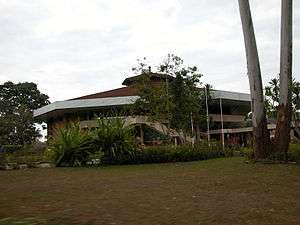
Chancellor College, University of Malawi | |
 Zomba Location in Malawi | |
| Coordinates: 15°23′S 35°20′E / 15.383°S 35.333°E | |
| Country |
|
| Region | Southern Region |
| District | Zomba District |
| Population (2008 est.) | |
| • Total | 101,140 |
| Time zone | +2 |
| Climate | Cwa |
Zomba is a city in southern Malawi, in the Shire Highlands. It is the administrative capital of Zomba District.
It was the capital of first British Central Africa and then Nyasaland before the establishment of the Republic of Malawi in 1964. It was also the first capital of Malawi and remained so until 1974, when Lilongwe became the capital. The Parliament remained even longer, until 1994 in Zomba. The city is best known for its British colonial architecture and its location at the base of the dramatic Zomba Plateau. Zomba is also the home of Chancellor College of the University of Malawi.
History
British colonial influence

The town's British colonial past is reflected in the architecture of its older buildings and homes. Zomba was once a hub for expatriates in Malawi. Its diverse cultural mix included British tobacco farmers and Dutch, German and U.S. emissaries. The British also established Sir Harry Johnston Primary School. The Zomba Gymkhana Club was once the focus for social activity in the expatriate community. However, in recent years, the club's appearance and reputation have been in decline. Next to the old parliament building is the botanical garden, which was established by the British, as well as the golf course in the city centre. At the southern entrance to the city, the King's African Rifles memorial is positioned right next to the M1.
Economy
Zomba is the centre for the tobacco and dairy farms of the surrounding area, which also produces rice, corn (maize), fish, and softwoods. Timber is extracted from the nearby plateau.
A market can be found in the town centre, where farmers from surrounding villages sell their products, as well as second hand clothes and basic consumer goods. Also fresh and dried fish from Lake Malawi and Lake Chilwa are sold. Local supermarkets, such as Peoples Trading Company, Metro and Shoprite are located near the bus depot. A dozen, mainly Indian and Chinese owned, shops sell imported clothes, electrical appliances, bicycles other and basic goods. Along the M1, several filling stations can be found. National Bank of Malawi, NBS savings Bank, Standard Bank and Opportunity Bank International as well as the Malawian Post have a branch in the city.
Zomba Hospital is an important employer and one of the biggest hospitals in the country.[1]
Zomba Central Prison was built in 1935 is the only maximum security prison in Malawi.
Tourism
The main attraction in Zomba is the Zomba Plateau. Activities offered include rock climbing, horse riding, bird watching, fishing and mountain-biking. The Ku Chawe Inn, situated right on the edge of the plateau, is the most luxurious hotel in the area. Tourists also can sleep in log houses or camp at the trout farm. Within the town, two backpacker hostels and several lodges, ranging from basic to mid-class, are open for guests. A craft market provides locally made souvenirs.
Education

University of Malawi
Chancellor College, the largest of the constituent colleges of the University of Malawi, is located in Zomba. The college has five faculties: Faculty of Humanities, Faculty of Science, Faculty of Law, Faculty of Social Science and Faculty of Education.
Sir Harry Johnston International Primary School
Sir Harry Johnston International School[2] has served the international and local community since the early 1950s. The school consists of a seven classroom block (pre-Nursery to year 6) and separate library. There is also a spacious hall building and a Secondary School on the grounds. Within the spacious and beautifully landscaped grounds there is a swimming pool, a seventy-metre soccer/games field, basketball court, nursery class play area, a volleyball court, netball field and smaller sized training pitches. The school is centrally located on Kalimbuka Road and offers an internationally adapted UK curriculum. The school has students from a diverse range of nationalities with around 85% of the students Malawian. The school is non-profit making and is managed by an elected board of governors from the parent community. The school's swimming-pool is open to public from September to May.
Zomba Catholic Secondary School
Located around 3 miles from the Old Capital city's town centre, this is a government funded school founded in the 1940s by the Catholic church. A community of Marist Brothers is located on site and the Brothers help with the teaching. Although funded by the government, pupils are still required to pay fees (MK18 500 per term as of 2011) as they live on campus and must pay board. The school is regarded as one of the best government schools in Malawi and competition for entry is intense. The school has around 300 pupils and 16 teachers as well as several administrative staff.
Zomba Theological College
Zomba Theological College was founded in 1977 and is run by the five synods of Blantyre, Livingsonia, Nkhoma, Harare and Zambia but also works closely with the theological department of the University of Malawi.[3]
Geography
Zomba Plateau
The Zomba Plateau is Zomba's most famous feature. In some parts, it rises to 1800 m in height and is covered with vast tracts of African juniper and Widdringtonia, and other mixed vegetation. The top of the plateau is criss-crossed by streams and is dotted with waterfalls and still lakes. The hike to the top of the Plateau is a popular tourist activity.
From the top of the plateau, it is possible to see Lake Chilwa to the north, Mount Mulanje to the southeast and the Shire River to the west. The Mulunguzi River springs from the plateau and flows through the town.
This is a good place to trek, as there is an abundance of plant life and creatures, as well as waterfalls.
Climate
| Climate data for Zomba | |||||||||||||
|---|---|---|---|---|---|---|---|---|---|---|---|---|---|
| Month | Jan | Feb | Mar | Apr | May | Jun | Jul | Aug | Sep | Oct | Nov | Dec | Year |
| Average high °C (°F) | 27 (80) |
27 (80) |
26 (79) |
26 (78) |
24 (76) |
22 (72) |
22 (72) |
24 (75) |
27 (81) |
29 (85) |
29 (85) |
27 (81) |
26 (79) |
| Average low °C (°F) | 18 (65) |
18 (65) |
18 (65) |
17 (62) |
14 (58) |
12 (54) |
12 (53) |
13 (55) |
15 (59) |
18 (64) |
19 (66) |
18 (65) |
16 (61) |
| Average precipitation mm (inches) | 307 (12.1) |
251 (9.9) |
257 (10.1) |
69 (2.7) |
18 (0.7) |
10 (0.4) |
8 (0.3) |
8 (0.3) |
5 (0.2) |
30 (1) |
109 (4.3) |
277 (10.9) |
1,344 (52.9) |
| Source: Weatherbase[4] | |||||||||||||
Fauna
The bird, the white-winged apalis (Apalis chariessa), has been sighted in the evergreen forest along the Mulunguzi River. It is estimated that only 100 pairs remain in the wild.
The eastern egg eater snake (Dasypeltis medici medici) has been found and several specimens recorded, including one of 112 cm.
Transportation
The easiest way to get to Zomba is by Kombi bus service from Lilongwe or Blantyre via the M1, Malawi's main north-south highway. National Bus Service as well as private run mini-buses connect Zomba with Liwonde, Mangochi, Balaka, Lilongwe and Lake Malawi. Trucks and pick-ups transport passengers to Mulanje and Phalombe. The highway between Zomba and Blantyre has been renovated and upgraded from 2012–2015.
North of the city lies an airstrip, which is owned and run by the Malawian military. The next scheduled airport is Chileka International Airport, 70 kilometres south of Zomba.
A railroad connects the western part of Zomba with Malawi Railways.
Public transport within the city is organised by minibuses. However, cycling and walking are the most widely used modes of transportation.
Demographics
| Year | Population[5] |
|---|---|
| 1977 | 24,234 |
| 1987 | 43,250 |
| 1998 | 64,115 |
| 2008 | 101,140 |
Religion

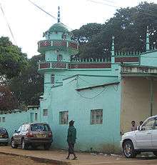
Zomba is influenced by the Muslim community of Yao and Muslim Malawians from Indian descent. The main mosque is close to the market.
Several Christian churches have branches in Zomba, the city is seat of the Roman Catholic Diocese of Zomba.
Sister cities
Since 2008, Zomba is a sister city with Urbana, Illinois.[6]
Gallery
 Eastern Region Police Headquarters, Zomba, Malawi
 Zomba District Council Building, in Zomba City
 Gymkhana CLub in Zomba, established 1923
 Zomba Plateau approached from the Blantyre-Zomba road, which was being renovated when this picture was taken in March 2014
 CCAP Church in Zomba with Zomba golf course and Zomba Plateau in the background
References
- ↑ Zomba Hospital | Malawi Goodlife
- ↑ http://www.sirharryszomba.com
- ↑ Zomba Theological College: Course and academic details
- ↑ "Weatherbase: Historical Weather for Zomba, Malawi". Weatherbase. 2011. Retrieved on 24 November 2011.
- ↑ World Gazetteer: Malawi: largest cities and towns and statistics of their population Archived 4 August 2008 at the Wayback Machine.
- ↑ "Urbana's Sister City Program—Zomba, Malawi". Retrieved 17 September 2011.
External links
| Wikimedia Commons has media related to Zomba. |
| Wikivoyage has a travel guide for Zomba. |
Coordinates: 15°23′S 35°20′E / 15.383°S 35.333°E
