Yazoo lands

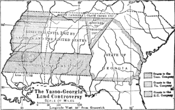
The Yazoo lands were the sparsely populated, central and western regions of the U.S. state of Georgia, when its western border stretched back to the Mississippi River.[1] The Yazoo lands were named for the Native American Yazoo tribe, that lived on the lower course of the Yazoo River, in what is now the present-day state of Mississippi.
The Yazoo lands would later, become large portions of the present-day states of Alabama and Mississippi, with the exclusion of Spanish West Florida, which became the lower third of each state, and a narrow northern strip of land claimed by South Carolina in the Treaty of Beaufort that also stretched westward to the river, which became the two states' border counties with Tennessee.[1]
In the 1790s, the Yazoo lands were the subject of a major political scandal in the state of Georgia, called the Yazoo land scandal. It led to Georgia's cession of the land to the U.S. government in the Compact of 1802.[1][2]
References
- 1 2 3 Pickett, Albert James (1851). History of Alabama and incidentally of Georgia and Mississippi, from the earliest period. Charleston: Walker and James. pp. 408–428.
- ↑ "The Pine Barrens Speculation and Yazoo Land Fraud". About North Georgia. Retrieved July 27, 2013.
See also
Coordinates: 32°54′N 88°18′W / 32.9°N 88.3°W