Vats (municipality)
| Vats herad | |
|---|---|
| Former Municipality | |
|
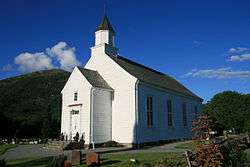
View of the municipal church | |
 Vats herad Location in Rogaland county | |
| Coordinates: 59°29′30″N 05°44′01″E / 59.49167°N 5.73361°ECoordinates: 59°29′30″N 05°44′01″E / 59.49167°N 5.73361°E | |
| Country | Norway |
| Region | Western Norway |
| County | Rogaland |
| District | Haugaland |
| Municipality ID | NO-1155 |
| Adm. Center | Vats |
| Area[1] | |
| • Total | 124 km2 (48 sq mi) |
| Time zone | CET (UTC+01:00) |
| • Summer (DST) | CEST (UTC+02:00) |
| Created from | Skjold in 1891 |
| Merged into | Vindafjord in 1965 |
Vats is a former municipality in Rogaland county, Norway. Located in the traditional district of Haugaland, the municipality existed from 1891 until 1965. The 124-square-kilometre (48 sq mi) municipality encompassed the land to the east and west surrounding the Vatsfjorden and the lake Vatsvatnet. Vats is typically divided into two parts Øvre Vats (around the lake in the north) and Nedre Vats (around the fjord in the south).[1]
History
The municipality of Vats was established on 1 January 1891 when it was split off from the municipality of Skjold (see formannskapsdistrikt). Initially, Vats had 1,095 residents. On 1 January 1965, the municipality was dissolved due to recommendations of the Schei Committee. The majority of Vats (population: 1,128) was merged with parts of Imsland, Skjold, and Vikedal, as well as all of Sandeid to form the new municipality of Vindafjord. On the same day, the Breidal and Stølsvik farms on the south side of the Yrkefjorden (population: 16) became a part of Tysvær municipality.[2]
References
- 1 2 Store norske leksikon. "Vats – tidligere kommune" (in Norwegian). Retrieved 2015-06-30.
- ↑ Jukvam, Dag (1999). "Historisk oversikt over endringer i kommune- og fylkesinndelingen" (PDF) (in Norwegian). Statistisk sentralbyrå.
