Typhoon Talim (2005)
| Typhoon (JMA scale) | |
|---|---|
| Category 4 (Saffir–Simpson scale) | |
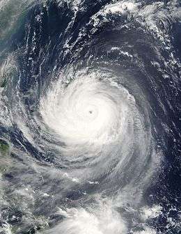
 Typhoon Talim approaching Taiwan on August 30, 2005 | |
| Formed | August 26, 2005 |
| Dissipated | September 1, 2005 |
| Highest winds |
10-minute sustained: 175 km/h (110 mph) 1-minute sustained: 240 km/h (150 mph) |
| Lowest pressure | 925 hPa (mbar); 27.32 inHg |
| Fatalities | 150 direct |
| Damage | $1.5 billion (2005 USD) |
| Areas affected | Taiwan, China |
| Part of the 2005 Pacific typhoon season | |
Typhoon Talim, known in the Philippines as Typhoon Isang, was a strong tropical cyclone that passed over Taiwan on the night of August 31 to September 1, 2005, and over Southeast China on September 2. At maximum intensity, Talim was a category 4 storm, just under super typhoon intensity. The name of the typhoon comes from the Tagalog term Talim, which means 'sharpness'.
Meteorological history

An area of convection which developed and persisted approximately 250 nmi east-northeast of Guam. It was first mentioned as a suspect area in JTWC's STWO issued at 06:00 UTC 24 August when satellite imagery revealed a broad LLCC associated with the disturbance. An upper-level analysis revealed a low to moderate wind shear environment. However, an upper-level LOW was impinging on the outflow on the northern side of the circulation. Despite this, the potential for development of a significant tropical cyclone was raised to 'good' at August 25 22:00 UTC and a TCFA issued. The first warning was released at 26/0600 UTC when Tropical Depression 13W was located approximately 100 nmi west-southwest of Guam. It was upgraded to a 35-kn tropical storm by both JTWC and JMA on August 27 00:00 UTC, the tropical cyclone being assigned the name Talim.
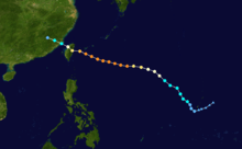
Tropical Storm Talim steadily intensified on 27 August as it moved on a general northwestward track along the southwestern periphery of a sub-tropical ridge. The tropical cyclone was raised to typhoon intensity at 0600 UTC 28 August when it was located approximately 690 nmi south-east of Okinawa. At this time, PAGASA christened the tropical cyclone: Isang after the storm had entered their AOR. Typhoon Talim continued to strengthen on 28 August while moving on a more westward heading and reached a peak intensity of 130 kn on August 29 18:00 UTC. After maintaining this strength for nearly 24 hours, a weakening trend began late on 30 August as the storm approached the island of Taiwan. Typhoon Talim made landfall near Hualien, Taiwan, on August 31 18:00 UTC with a MSW of 95 kn. From there, the cyclone crossed the Taiwan Strait and came ashore near Fuzhou, China, around September 1 06:00 UTC, the same time that it was downgraded to a 55-kn tropical storm. JTWC issued the final warning on the same day while JMA continued to maintain the system as a tropical storm, downgrading Talim to a tropical depression at September 2 06:00 UTC. The last statement issued by JMA was later that day.
Impact
Taiwan

At least 7 people were reported killed in the storm. The typhoon left the island later that day and headed towards China.
Typhoon Talim was the second storm of such strength to hit Taiwan during the 2005 storm season, the first time since 1994.
Mainland China
More than 15 million people were affected by the storm. At least 110 people were reported dead in eastern China, mainly because of floods and landslides. A further 28 people were reported missing. More than 150,000 people were evacuated, and thousands of homes were damaged or destroyed. The Ministry of Civil Affairs in China reported that the typhoon caused 12.19 billion yuan (about US$1.5 billion) of economic losses. [1]
Philippines
In the Philippines, no one was reported hurt, missing, or dead, but heavy rains were experienced as Talim lashed through the island of Luzon.
References
- ↑ "Talim leaves 95 dead, 30 missing". China View. 2005-09-05.
- Typhoon Talim (Isang) (CNN)
- Typhoon kills 11 in China, three in Taiwan (Metronews)
- Typhoon death toll rises in China, BBC, 5 September 2005
- Typhoon Talim leaves 95 dead, 30 missing: ministry (Xinhua)
External links
| Wikimedia Commons has media related to Typhoon Talim (2005). |
- JMA General Information of Typhoon Talim (0513) from Digital Typhoon
- JMA Best Track Data of Typhoon Talim (0513) (Japanese)
- JMA Best Track Data (Graphics) of Typhoon Talim (0513)
- JMA Best Track Data (Text)
- JTWC Best Track Data of Super Typhoon 13W (Talim)
- 13W.TALIM from the U.S. Naval Research Laboratory
- Gary Pagdett's Monthly Global Tropical Cyclone Summary
