Trofa
| Trofa | |||
|---|---|---|---|
| Municipality | |||
|
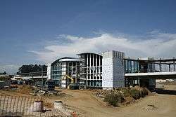
Trofa train station under construction | |||
| |||
 | |||
| Coordinates: 41°21′N 8°33′W / 41.350°N 8.550°WCoordinates: 41°21′N 8°33′W / 41.350°N 8.550°W | |||
| Country |
| ||
| Region | Norte | ||
| Subregion | Ave | ||
| Metropolitan area | Porto | ||
| District | Porto | ||
| Government | |||
| • President | Sérgio Humberto Silva (PSD/CDS) | ||
| Area | |||
| • Total | 72.02 km2 (27.81 sq mi) | ||
| Population (2011) | |||
| • Total | 38,999 | ||
| • Density | 540/km2 (1,400/sq mi) | ||
| Time zone | WET/WEST (UTC+0/+1) | ||
| Website | http://www.mun-trofa.pt/ | ||
Trofa (Portuguese pronunciation: [ˈtɾɔfɐ]) is a municipality in the north of the Porto metropolitan area in Portugal. The population in 2011 was 38,999,[1] in an area of 72.02 km².[2]
Trofa has a strong industrial park, with various types of industry including pharmaceutical, metalworking and textile industries.
The city centre is formed by the parish Bougado (São Martinho e Santiago). Another important center in the municipality is Coronado.
Parishes
Although in the beginning of the municipality, it had 8 parishes, with the administrative changes in 2013, is divided into 5 civil parishes (freguesias):[3]
- Alvarelhos e Guidões
- Bougado (São Martinho e Santiago)
- Coronado (São Romão e São Mamede)
- Covelas
- Muro
History
Trofa has had an important role due to its geographic location between Porto and Braga/Guimarães, being located in the border of Douro and Minho, but still inside of the district of Porto, which led to Trofa being mentioned in the time of the Roman Empire ("trofa" means frontier in Arab). An important factor of its growth was the construction of railways in the beginning of the 20th century, which led to rapid growth.
References
- ↑ Instituto Nacional de Estatística
- ↑ Direção-Geral do Território
- ↑ Diário da República. "Law nr. 11-A/2013, pages 552 123-124" (pdf) (in Portuguese). Retrieved 4 August 2014.
External links
| Wikimedia Commons has media related to Trofa. |


