Trails of the Chattahoochee National Forest
- Trails of the Oconee National Forest are described here.
There are 86 trails maintained by the U.S. Forest Service in the Chattahoochee National Forest in the State of Georgia. [1] These trails include:

Map showing trails of Georgia

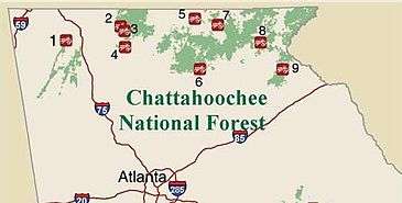
Map showing location of Off Highway Vehicle (OHV) trails
| Trail Name | Ranger District |
|---|---|
| Anderson Creek ORV Trails | Toccoa |
| Andrews Cove Trail | Chattooga |
| Angel Falls Trail | Tallulah |
| Anna Ruby Falls Trail | Chattooga |
| Appalachian Trail[2] | Brasstown, Chattooga, Toccoa & Tallulah |
| Arkaquah Trail | Armuchee-Cohutta |
| Aska Trails[3] | Toccoa |
| Bartram Trail[4] | Tallulah |
| Bear Creek Trail | Armuchee-Cohutta |
| Bear Hair Gap Trail | Brasstown |
| Beasley Knob ORV Trails[5] | Brasstown |
| Benton MacKaye Trail | Armuchee-Cohutta & Toccoa |
| Brasstown Bald Trail | Brasstown |
| Broad River Trail | Chattooga |
| Bull Mountain Multi-Use Trail | Toccoa |
| Byron Herbert Reece Access | Brasstown |
| Chattooga River Trail | Tallulah |
| Chickamuaga Creek Trail | Armuchee-Cohutta |
| Coleman River Trail | Tallulah |
| Cooper Creek Trail | Brasstown |
| Coosa Backcountry Trail | Brasstown |
| Davenport Trail[6] | Brasstown |
| Desoto Falls Trail | Brasstown |
| Dockery Lake Trail | Brasstown |
| Dukes Creek Trail | Chattooga |
| Duncan Ridge Trail | Brasstown & Toccoa |
| Emery Creek Trail | Armuchee-Cohutta |
| "Eyes on Wildlife" Trail | Toccoa |
| Freeman Trail | Brasstown |
| Grassy Mountain Trail | Armuchee-Cohutta |
| Helton Creek Falls Trail | Brasstown |
| Hemlock Trail | Tallulah |
| High Shoals Trail | Brasstown |
| Holcomb Creek Trail | Tallulah |
| Horsetrough Falls Trail | Chattooga |
| Houston Valley ORV Area[7] | Armuchee-Cohutta |
| Iron Mountain Trail | Armuchee-Cohutta |
| Jacks Knob Trail | Brasstown |
| Jarrard Gap Trail | Brasstown |
| Johns Mountain Trail | Armuchee-Cohutta |
| Keown Falls Trail | Armuchee-Cohutta |
| Ladyslipper Trail | Chattooga |
| Lake Blue Ridge Trail | Toccoa |
| Lake Chatuge Trail | Brasstown |
| Lake Consuaga Trail | Armuchee-Cohutta |
| Lake Russell Trail | Chattooga |
| Lake Winfield Scott Trail | Brasstown |
| Lakeshore Trail | Brasstown |
| Locust Stake ORV Area[8] | Chattooga |
| Logan Turnpike Trail | Chattooga |
| Mills Shoals Trail | Brasstown |
| Milma Creek ATV Trail[9] | Armuchee-Cohutta |
| Minnehaha Trail | Tallulah |
| Moates Knob Trail[10] | Chattooga |
| Mountaintown Creek Trail | Armuchee-Cohutta |
| Murrays Lake Trail | Armuchee-Cohutta |
| Oakey Mountain ORV Trail[10] | Tallulah |
| Panther Creek Trail | Chattooga |
| Pocket Trail | Armuchee-Cohutta |
| Rabun Bald Trail | Tallulah |
| Raven Cliffs Trail | Chattooga |
| Raven Rock Trail | Tallulah |
| Rock Creek ATV Trail[11] | Armuchee-Cohutta |
| Rocky Falts ORV Trail[12] | Armuchee-Cohutta |
| Rocky Mountain Trail | Brasstown |
| Shope Gap Trail | Brasstown |
| Slaughter Creek Trail | Brasstown |
| Smith Creek Trail | Chattooga |
| Songbird Trail | Armuchee-Cohutta |
| Sosebee Cove Trail | Brasstown |
| Sourwood Trail | Chattooga |
| South Fork Trail | Armuchee-Cohutta |
| Stanley Creek Trail | Toccoa |
| Sumac Creek Trail | Armuchee-Cohutta |
| Sutton Hole Trail | Tallulah |
| Tatum Lead ORV Trail[11] | Armuchee-Cohutta |
| Taylors Ridge Trail | Armuchee-Cohutta |
| Three Forks Trail | Tallulah |
| Tibbs ORV Trail[9] | Armuchee-Cohutta |
| Toccoa River Canoe Trail | Toccoa |
| Turner Creek Multi-Use Trail | Toccoa |
| Wagon Train Trail | Brasstown |
| Warwoman Dell Nature Trail | Tallulah |
| Whissenhunt ORV Trails[13] | Toccoa |
| Willis Knob | Tallulah |
| Windy Gap Cycle Trail[9] | Armuchee-Cohutta |
| Yellow Mountain Trail | Brasstown |
References
- ↑ Trail Brochure for the Forest
- ↑ See also Appalachian Trail in Georgia
- ↑ Aska Trails Information
- ↑ The Bartram Trail
- ↑ Located at #7 on the OHV Map, See also Beasley Knob Trail Information
- ↑ Located at #5 on the OHV Map, See also Davenport Trail Information
- ↑ Located at #1 on the OHV Map, See also Houston Valley Trail Information
- ↑ Located at #9 on the OHV Map, See also Locust Stake Trail Information
- 1 2 3 Located at #3 on the OHV Map, See also Windy Gap, Milma Creek & Tibbs Trail Information
- 1 2 Located at #8 on the OHV Map, See also Oakey Mountain & Moates Knob Trail Information
- 1 2 Located at #4 on the OHV Map, See also Rock Creek and Tatum Lead Information
- ↑ Located at #2 on the OHV Map, See also Rocky Flats Trail Information
- ↑ Located at #6 on the OHV Map, See also Wissenhunt Trail Information
This article is issued from Wikipedia - version of the 7/4/2016. The text is available under the Creative Commons Attribution/Share Alike but additional terms may apply for the media files.
