Timeline of the 2016 Pacific hurricane season

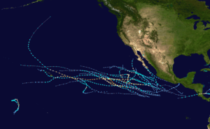
The 2016 Pacific hurricane season is an ongoing event in the annual cycle of tropical cyclone formation, in which tropical cyclones form in the eastern Pacific Ocean. The season officially started on May 15 in the eastern Pacific—east of 140°W—and on June 1 in the central Pacific—between the International Date Line and 140°W—and will last until November 30. These dates typically cover the period of each year when most tropical cyclones form in the eastern Pacific basin.[1] However the first storm, Pali, formed 5 months before the official start of the season on January 7, which broke the record for having the earliest forming storm within the basin.
So far, seven tropical depressions developed, six of which became tropical storms. Four of the tropical storms reached hurricane strength, with two achieving major hurricane intensity.[nb 1] With the formation of Estelle, the season has had record amount of named storms in July, with six.
Four time zones are utilized in the basin: Central for storms east of 106°W, Mountain between 114.9°W and 106°W, Pacific between 140°W and 115°W,[3] and Hawaii–Aleutian for storms between the International Date Line and 140°W. However, for convenience, all information is listed by Coordinated Universal Time (UTC) first with the respective local time included in parentheses. This timeline includes information that was not operationally released, meaning that data from post-storm reviews by the National Hurricane Center is included. This timeline documents tropical cyclone formations, strengthening, weakening, landfalls, extratropical transitions, and dissipations during the season.
Timeline of events

January
- January 1
- 03:00 UTC (5:00 p.m. HST, December 31, 2015) at 2°48′N 178°18′W / 2.8°N 178.3°W — 2016 opens with Tropical Depression Nine-C weakening and remaining disorganized near the International Dateline and the equator.[4]
- 09:00 UTC (11:00 p.m. HST, December 31, 2015) at 2°12′N 176°42′W / 2.2°N 176.7°W — Tropical Depression Nine-C degenerates into a remnant low about 1,115 miles (1,795 km)[nb 2] south-southwest of Johnston Island, which makes it an end for the previous season.[5]
- January 7
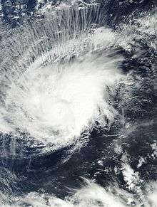
- 15:00 UTC (5:00 a.m. HST) at 4°00′N 171°24′W / 4.0°N 171.4°W — Tropical Depression One-C develops from an area of thunderstorms and moisture from the previous storm 885 miles (1,425 km) south of Johnston Island.[6]
- 21:00 UTC (11:00 a.m. HST) at 4°00′N 171°24′W / 4.0°N 171.4°W — With an increase of organization, Tropical Depression One-C strengthens into Tropical Storm Pali while located about 835 miles (1,345 km) south of Johnston Island.[7]
- January 12

- 03:00 UTC (5:00 p.m. HST, January 11) at 8°06′N 171°54′W / 8.1°N 171.9°W — Tropical Storm Pali strengthens into a Category 1 hurricane, which also became the earliest recorded hurricane within the basin while located about 615 miles (990 km) south-southwest of Johnston Island.[8]
- 21:00 UTC (11:00 a.m. HST) at 6°12′N 171°18′W / 6.2°N 171.3°W — Hurricane Pali strengthens into a Category 2 hurricane about 735 miles (1,185 km) south of Johnston Island. It simultaneously achieves its peak strength with winds of 100 mph (155 km/h) and a pressure of 977 mbar (hPa; 28.85 inHg).[9]
- January 13
- 09:00 UTC (11:00 p.m. HST, January 12) at 4°54′N 171°30′W / 4.9°N 171.5°W — Hurricane Pali weakens to a Category 1 hurricane roughly 825 miles (1,330 km) south of Johnston Island.[10]
- January 14
- 03:00 UTC (5:00 p.m. HST, January 13) at 2°42′N 172°12′W / 2.7°N 172.2°W — Hurricane Pali weakens to a tropical storm about 330 miles (530 km) east-northeast of Howland Island.[11]
- 15:00 UTC (5:00 a.m. HST) at 2°30′N 173°00′W / 2.5°N 173.0°W — Tropical Storm Pali rapidly weakens to a tropical depression approximately 1,010 miles (1,625 km) south-southwest of Johnston Island.[12]
- January 15
- 03:00 UTC (5:00 p.m. HST) at 1°42′N 173°12′W / 1.7°N 173.2°W — Tropical Depression Pali degenerates into a remnant low about 1,065 miles (1,715 km) south-southwest of Johnston Island.[13]
May
- May 15
- The 2016 Pacific hurricane season officially begins.[1]
June
- June 6
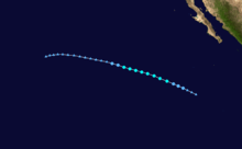
- 21:00 UTC (4:00 p.m. CDT) at 14°12′N 97°00′W / 14.2°N 97.0°W — Tropical Depression One-E develops from an area of low pressure roughly 185 mi (295 km) southwest of Salina Cruz, Mexico.[14]
- June 7
- 00:00 UTC (7:00 p.m. CDT, June 6) at 14°18′N 96°42′W / 14.3°N 96.7°W – Tropical Depression One-E achieves its peak intensity with maximum sustained winds of 35 mph (55 km/h) and a barometric pressure of 1006 mbar (hPa; 29.71 inHg) while situated 165 mi (265 km) southwest of Salina Cruz, Mexico.[15]
- June 8
- 15:00 UTC (10:00 a.m. CDT) at 16°24′N 94°48′W / 16.4°N 94.8°W – Tropical Depression One-E degenerates to a remnant low about 30 mi (50 km) east-northeast of Salina Cruz, Mexico.[16]
July
- July 2

- 03:00 UTC (8:00 p.m. PDT July 1) at 14°42′N 116°54′W / 14.7°N 116.9°W — Tropical Depression Two-E develops from an area of low pressure roughly 730 mi (1,170 km) southwest of the southern tip of Baja California.[17]
- 15:00 UTC (8:00 a.m. PDT) at 15°36′N 118°54′W / 15.6°N 118.9°W — Tropical Depression Two-E becomes Tropical Storm Agatha about 775 mi (1,245 km) southwest of the southern tip of Baja California.[18]
- July 3
- 03:00 UTC (9:00 p.m. MDT July 2) at 11°06′N 108°18′W / 11.1°N 108.3°W — Tropical Depression Three-E develops form about 605 mi (975 km) south-southwest of Manzanillo, Mexico.[19]
- 09:00 UTC (2:00 a.m. PDT) at 17°00′N 122°48′W / 17.0°N 122.8°W – Tropical Storm Agatha reaches its peak intensity with maximum sustained winds of 45 mph (75 km/h) and a barometric pressure of 1003 mbar (hPa; 29.62 inHg) while situated approximately 930 mi (1,495 km) west-southwest of the southern tip of Baja California.[20]
- 09:00 UTC (3:00 a.m. MDT) at 11°42′N 109°42′W / 11.7°N 109.7°W — Tropical Depression Three-E strengthens into Tropical Storm Blas roughly 620 mi (995 km) southwest of Manzanillo, Mexico.[21]
- July 4
- 15:00 UTC (9:00 a.m. MDT) at 13°18′N 114°24′W / 13.3°N 114.4°W — Tropical Storm Blas strengthens into a Category 1 hurricane about 725 mi (1,170 km) south-southwest of the southern tip of Baja California.[22]
- 21:00 UTC (2:00 p.m. PDT) at 18°48′N 129°24′W / 18.8°N 129.4°W — Tropical Storm Agatha weakens to a tropical depression about 1,290 mi (2,075 km) west of the southern tip of Baja California.[23]
- July 5
- 03:00 UTC (8:00 p.m. PDT July 4) at 19°18′N 130°24′W / 19.3°N 130.4°W — Tropical Depression Agatha degenerates into a remnant low approximately 1,345 mi (2,160 km) west of the southern tip of Baja California.[24]
- 09:00 UTC (2:00 a.m. PDT) at 14°12′N 118°06′W / 14.2°N 118.1°W — Hurricane Blas strengthens into a Category 2 hurricane roughly 805 mi (1,295 km) southwest of the southern tip of Baja California.[25]
- 21:00 UTC (2:00 p.m. PDT) at 14°18′N 120°54′W / 14.3°N 120.9°W — Hurricane Blas rapidly intensifies into a Category 3 hurricane roughly 930 mi (1,500 km) southwest of the southern tip of Baja California.[26]
- July 6

- 03:00 UTC (8:00 p.m. PDT July 5) at 14°24′N 121°42′W / 14.4°N 121.7°W – Hurricane Blas strengthens into a Category 4 hurricane, reaching its peak intensity with maximum sustained winds of 140 mph (220 km/h) and a barometric pressure of 947 mbar (hPa; 27.97 inHg) while situated approximately 970 mi (1,560 km) southwest of the southern tip of Baja California.[27]
- 09:00 UTC (2:00 a.m. PDT) at 14°42′N 122°42′W / 14.7°N 122.7°W – Hurricane Blas weakens to a strong Category 3 hurricane roughly 1,010 mi (1,625 km) southwest of the southern tip of Baja California.[28]
- 21:00 UTC (3:00 p.m. MDT) at 12°12′N 109°06′W / 12.2°N 109.1°W – Tropical Depression Four-E forms from an area of low pressure about 570 mi (915 km) southwest of Manzanillo, Mexico.[29]
- July 8
- 03:00 UTC (8:00 p.m. PDT July 7) at 16°54′N 128°36′W / 16.9°N 128.6°W – Hurricane Blas weakens to a Category 2 hurricane roughly 1,280 mi (2,060 km) west-southwest of the southern tip of Baja California.[30]
- 21:00 UTC (2:00 p.m. PDT) at 18°30′N 130°30′W / 18.5°N 130.5°W – Hurricane Blas weakens to a Category 1 hurricane roughly 1,365 mi (2,195 km) west of the southern tip of Baja California.[31]
- July 9
- 09:00 UTC (2:00 a.m. PDT) at 19°30′N 131°42′W / 19.5°N 131.7°W – Hurricane Blas rapidly weakens to a tropical storm roughly 1,420 mi (2,290 km) west of the southern tip of Baja California.[32]
- July 10
- 09:00 UTC (2:00 a.m. PDT) at 21°12′N 135°12′W / 21.2°N 135.2°W — Tropical Storm Blas weakens to a tropical depression about 1,290 mi (2,075 km) east of Hilo, Hawaii.[33]
- 15:00 UTC (8:00 a.m. PDT) at 21°18′N 136°18′W / 21.3°N 136.3°W — Tropical Depression Blas degenerates into a remnant low approximately 1,220 mi (1,965 km) east of Hilo, Hawaii.[34]
- July 11
- July 12
- July 13
- July 14
- July 15
- July 16
- July 18
- July 20
- July 21
- July 22
- July 24
- July 25
- July 26
- July 27
- July 28
- July 29
- July 31
August
- August 1
- August 2
- August 3
- August 7
- August 8
- August 9
- August 15
- August 18
- August 19
- August 21
- August 23
- August 24
- August 26
- August 27
- August 29
- August 30
September
- September 1
- September 2
November
November 30
- The 2016 Pacific hurricane season officially ends.[1]
See also
Notes
- ↑ A major hurricane is a storm that ranks as Category 3 or higher on the Saffir–Simpson hurricane wind scale.[2]
- ↑ The figures for maximum sustained winds and position estimates are rounded to the nearest 5 units (knots, miles, or kilometers), following the convention used in the National Hurricane Center's operational products for each storm. All other units are rounded to the nearest digit.
References
- 1 2 3 Christopher W. Landsea; Neal Dorst; Erica Rule (June 2, 2011). "G: Tropical Cyclone Climatology". Hurricane Research Division: Frequently Asked Questions. Atlantic Oceanographic and Meteorological Laboratory. National Oceanic and Atmospheric Administration. G1) When is hurricane season ?. Retrieved December 6, 2015.
- ↑ Lansea, Christopher W. (June 2, 2011). "A: Basic Definitions". In Dorst, Neal. Hurricane Research Division: Frequently Asked Questions. Atlantic Oceanographic and Meteorological Laboratory. National Oceanic and Atmospheric Administration. A3) What is a super-typhoon? What is a major hurricane ? What is an intense hurricane ?. Retrieved May 31, 2015.
- ↑ Robbie Berg (May 28, 2015). Tropical Depression One-E Discussion Number 1. National Hurricane Center (Report). Miami, Florida: National Oceanic and Atmospheric Administration. Retrieved June 27, 2015.
- ↑ "Tropical Depression Nine-C Discussion Number 5". Central Pacific Hurricane Center. National Oceanic and Atmospheric Administration. January 1, 2016. Retrieved January 1, 2016.
- ↑ "Tropical Depression Nine-C Discussion Number 6". Central Pacific Hurricane Center. National Oceanic and Atmospheric Administration. January 1, 2016. Retrieved January 1, 2016.
- ↑ "Tropical Depression One-C Advisory Number 1". Central Pacific Hurricane Center. National Oceanic and Atmospheric Administration. January 7, 2016. Retrieved January 7, 2016.
- ↑ "Tropical Storm Pali Advisory Number 2". Central Pacific Hurricane Center. National Oceanic and Atmospheric Administration. January 7, 2016. Retrieved January 7, 2016.
- ↑ "Hurricane Pali Advisory Number 19". Central Pacific Hurricane Center. National Oceanic and Atmospheric Administration. January 12, 2016. Retrieved January 12, 2016.
- ↑ "Hurricane Pali Advisory Number 22". Central Pacific Hurricane Center. National Oceanic and Atmospheric Administration. January 12, 2016. Retrieved January 12, 2016.
- ↑ "Hurricane Pali Discussion Number 24". Central Pacific Hurricane Center. National Oceanic and Atmospheric Administration. January 13, 2016. Retrieved March 3, 2016.
- ↑ "Tropical Storm Pali Advisory Number 27". Central Pacific Hurricane Center. National Oceanic and Atmospheric Administration. January 14, 2016. Retrieved March 3, 2016.
- ↑ "Tropical Depression Pali Advisory Number 29". Central Pacific Hurricane Center. National Oceanic and Atmospheric Administration. January 14, 2016. Retrieved March 3, 2016.
- ↑ "Remnants of Pali Advisory Number 31". Central Pacific Hurricane Center. National Oceanic and Atmospheric Administration. January 15, 2016. Retrieved May 19, 2016.
- ↑ John Cangialosi (June 6, 2016). "Tropical Depression One-E Advisory Number 1". National Oceanic and Atmospheric Administration. National Hurricane Center. Retrieved June 6, 2016.
- ↑ John Cangialosi (June 7, 2016). "Tropical Depression One-E Advisory Number 1A". National Oceanic and Atmospheric Administration. National Hurricane Center. Retrieved June 7, 2016.
- ↑ John Cangialosi (June 8, 2016). "Tropical Depression One-E Advisory Number 8". National Oceanic and Atmospheric Administration. National Hurricane Center. Retrieved June 8, 2016.
- ↑ Robbie Berg (July 1, 2016). "Tropical Depression Two-E Advisory Number 1". National Hurricane Center. National Oceanic and Atmospheric Administration. Retrieved July 25, 2016.
- ↑ Beven (July 2, 2016). "Tropical Storm Agatha Advisory Number 3". National Hurricane Center. National Oceanic and Atmospheric Administration. Retrieved July 25, 2016.
- ↑ Brennan (July 2, 2016). "Tropical Depression Three-E Advisory Number 1". National Hurricane Center. National Oceanic and Atmospheric Administration. Retrieved July 25, 2016.
- ↑ Stewart (July 3, 2016). "Tropical Storm Agatha Advisory Number 6". National Hurricane Center. National Oceanic and Atmospheric Administration. Retrieved July 25, 2016.
- ↑ Stewart (July 3, 2016). "Tropical Storm Blas Advisory Number 2". National Hurricane Center. National Oceanic and Atmospheric Administration. Retrieved July 25, 2016.
- ↑ Kimberlain (July 4, 2016). "Hurricane Blas Advisory Number 7". National Hurricane Center. National Oceanic and Atmospheric Administration. Retrieved July 27, 2016.
- ↑ Pasch (July 4, 2016). "Tropical Depression Agatha Advisory Number 12". National Hurricane Center. National Oceanic and Atmospheric Administration. Retrieved July 25, 2016.
- ↑ Brown (July 4, 2016). "Post-Tropical Cyclone Agatha Advisory Number 13". National Hurricane Center. National Oceanic and Atmospheric Administration. Retrieved July 25, 2016.
- ↑ Stewart (July 5, 2016). "Hurricane Blas Advisory Number 10". National Hurricane Center. National Oceanic and Atmospheric Administration. Retrieved July 27, 2016.
- ↑ Beven (July 5, 2016). "Hurricane Blas Advisory Number 12". National Hurricane Center. National Oceanic and Atmospheric Administration. Retrieved July 27, 2016.
- ↑ Cangialosi (July 5, 2016). "Hurricane Blas Advisory Number 13". National Hurricane Center. National Oceanic and Atmospheric Administration. Retrieved July 25, 2016.
- ↑ Brennan (July 6, 2016). "Hurricane Blas Advisory Number 14". National Hurricane Center. National Oceanic and Atmospheric Administration. Retrieved August 2, 2016.
- ↑ Beven (July 6, 2016). "Tropical Depression Four-E Advisory Number 1". National Hurricane Center. National Oceanic and Atmospheric Administration. Retrieved August 2, 2016.
- ↑ Roberts (July 7, 2016). "Hurricane Blas Advisory Number 21". National Hurricane Center. National Oceanic and Atmospheric Administration. Retrieved August 2, 2016.
- ↑ Brown (July 8, 2016). "Hurricane Blas Advisory Number 24". National Hurricane Center. National Oceanic and Atmospheric Administration. Retrieved August 2, 2016.
- ↑ Brennan (July 9, 2016). "Hurricane Blas Advisory Number 26". National Hurricane Center. National Oceanic and Atmospheric Administration. Retrieved August 2, 2016.
- ↑ Brennan (July 10, 2016). "Tropical Depression Blas Advisory Number 30". National Hurricane Center. National Oceanic and Atmospheric Administration. Retrieved July 25, 2016.
- ↑ Cangialosi (July 10, 2016). "Post-Tropical Cyclone Blas Advisory Number 31". National Hurricane Center. National Oceanic and Atmospheric Administration. Retrieved July 25, 2016.
External links
| Wikimedia Commons has media related to 2016 Pacific hurricane season. |
- The National Hurricane Center's 2016 Tropical Cyclone Advisory Archive
- The National Hurricane Center's Tropical Cyclone Reports for the 2016 Eastern Pacific hurricane season
- The Central Pacific Hurricane Center's Tropical Cyclone Advisory Archive
| Preceded by 2015 |
Pacific hurricane season timelines 2016 |
Succeeded by 2017 |