Tenasillahe Island
|
Tenasillahe Island can be seen in the lower central portion of the image. | |
| Geography | |
|---|---|
| Coordinates | 46°13′45″N 123°27′22″W / 46.22917°N 123.45611°WCoordinates: 46°13′45″N 123°27′22″W / 46.22917°N 123.45611°W |
| Adjacent bodies of water | Columbia River |
| Highest elevation | 2 m (7 ft) |
| Administration | |
| State | Oregon |
| County | Clatsop |
| Demographics | |
| Population | 0 |

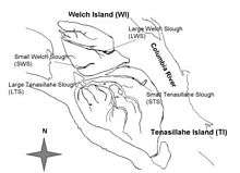
Map of Tenasillahe and Welch Islands
Tenasillahe Island is an island in the Columbia River Estuary portion of the Columbia River in Clatsop County, Oregon.[1] It is separated from the mainland and the unincorporated community of Clifton, Oregon by the Clifton Channel, and from nearby Welch Island by the Red Slough.[2]
The island was visited by the Lewis and Clark Expedition, and Tenasillahe and Welch were known as the "Marshy Islands".
The entire island is part of the Julia Butler Hansen Refuge for the Columbian White-tailed Deer.
Etymology
The name "Tenasillahe Island" is tautological, in that "Tenasillahe" means "island" in the Chinook language.
References
- ↑ "Tenasillahe Island Restoration Project". U.S. Fish and Wildlife Service. February 14, 2012. Retrieved November 13, 2016.
- ↑ "Tenasillahe Island". The Columbia River – A Photographic Journey. August 2012. Retrieved November 13, 2016.
This article is issued from Wikipedia - version of the 11/24/2016. The text is available under the Creative Commons Attribution/Share Alike but additional terms may apply for the media files.