Tankanqucha
| Tankanqucha | |
|---|---|
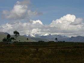 Wallanka and Tankanqucha as seen from the archaeological site of Wanuku Pampa | |
| Highest point | |
| Elevation | 5,200 m (17,100 ft) [1] |
| Coordinates | 9°54′31″S 77°03′12″W / 9.90861°S 77.05333°WCoordinates: 9°54′31″S 77°03′12″W / 9.90861°S 77.05333°W |
| Geography | |
 Tankanqucha Peru | |
| Location | Peru, Ancash Region |
| Parent range | Andes, Wallanka |
Tankanqucha (Quechua tanka fork, a deep bifurcation, -n a suffix, qucha lake,[2][3] "lake of the bifurcation", hispanicized spelling Tancancocha) is a mountain in the north of the Wallanka mountain range in the Andes of Peru at a small lake of that name.[4] The mountain reaches an altitude of approximately 5,200 m (17,100 ft). It is located in the Ancash Region, Bolognesi Province, in the districts of Aquia and Huallanca.[1]
The lake named Tankanqucha lies in the Huallanca District[1][4] at 9°53′55″S 77°02′56″W / 9.89861°S 77.04889°W, northeast of the peak.
References
- 1 2 3 escale.minedu.gob.pe - UGEL map of the Bolognesi Province (Ancash Region) see Nevado Burro (NW)
- ↑ Diccionario Quechua - Español - Quechua, Academía Mayor de la Lengua Quechua, Gobierno Regional Cusco, Cusco 2005 (Quechua-Spanish dictionary)
- ↑ Teofilo Laime Ajacopa, Diccionario Bilingüe Iskay simipi yuyayk'ancha, La Paz, 2007 (Quechua-Spanish dictionary)
- 1 2 Alfred J. Bodenlos, George E. Ericksen, Lead-Zing Deposits of Cordillera Blanca and Northern Cordillera Huayhuash, Peru, Geological Survey Bulletin 1017, see. sketch maps p.9-10
This article is issued from Wikipedia - version of the 12/15/2015. The text is available under the Creative Commons Attribution/Share Alike but additional terms may apply for the media files.