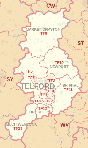
TF postcode area
Postcode district boundaries: Bing / Google
| Telford postcode area | |
|---|---|
 TF | |
| Postcode area | TF |
| Postcode area name | Telford |
| Post towns | 6 |
| Postcode districts | 13 |
| Postcode sectors | 43 |
| Postcodes (live) | 6,624 |
| Postcodes (total) | 8,642 |
| Statistics as at February 2012[1] | |
The TF postcode area, also known as the Telford postcode area,[2] is a group of thirteen postcode districts in England, which are subdivisions of six post towns. These postcode districts cover north-east Shropshire, including Telford, Broseley, Market Drayton, Much Wenlock, Newport and Shifnal, plus a very small part of Staffordshire.
Coverage
The approximate coverage of the postcode districts:
| Postcode district | Post town | Coverage | Local authority area |
|---|---|---|---|
| TF1 | TELFORD | Wellington, Leegomery, Hadley, Ketley, Arleston, Hortonwood | Telford & Wrekin |
| TF2 | TELFORD | Oakengates, Priorslee, St. Georges, Donnington, Wrockwardine Wood, Muxton | Telford & Wrekin |
| TF3 | TELFORD | Telford Town Centre and Park, Hollinswood, Randlay, Stirchley, Brookside, Stafford Park | Telford & Wrekin |
| TF4 | TELFORD | Dawley, Malinslee, Lawley, Horsehay | Telford & Wrekin |
| TF5 | TELFORD | Admaston, Bratton, Shawbirch | Telford & Wrekin |
| TF6 | TELFORD | The Wrekin, Wrockwardine, Longden-upon-Tern, High Ercall | Telford & Wrekin |
| TF7 | TELFORD | Madeley, Woodside, Sutton Hill, Halesfield | Telford & Wrekin |
| TF8 | TELFORD | Ironbridge, Coalbrookdale, Coalport, Jackfield | Telford & Wrekin |
| TF9 | MARKET DRAYTON | Market Drayton, Loggerheads, Hodnet, Ternhill | Shropshire, Newcastle-under-Lyme |
| TF10 | NEWPORT | Newport, Lilleshall, Edgmond, Moreton | Telford & Wrekin, Stafford |
| TF11 | SHIFNAL | Shifnal, Tong, Weston-under-Lizard | Shropshire, South Staffordshire |
| TF12 | BROSELEY | Broseley | Shropshire |
| TF13 | MUCH WENLOCK | Much Wenlock | Shropshire |
Map
See also
References
- ↑ "ONS Postcode Directory Version Notes" (ZIP). National Statistics Postcode Products. Office for National Statistics. February 2012. Table 2. Retrieved 21 April 2012. Coordinates from mean of unit postcode points, "Code-Point Open". OS OpenData. Ordnance Survey. February 2012. Retrieved 21 April 2012.
- ↑ Royal Mail, Address Management Guide, (2004)
External links
- Royal Mail's Postcode Address File
- A quick introduction to Royal Mail's Postcode Address File (PAF)
- Using Welsh alternative addresses within Royal Mail's Postcode Address File (PAF)
This article is issued from Wikipedia - version of the 7/30/2016. The text is available under the Creative Commons Attribution/Share Alike but additional terms may apply for the media files.
