Sugarloaf Mountain (Dutchess County, New York)
| Sugarloaf Mountain | |
|---|---|
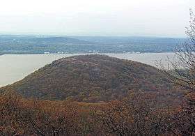
 Sugarloaf from the Breakneck Bypass Trail | |
| Highest point | |
| Elevation | 900 ft (270 m) [1] |
| Prominence | 300 ft (91 m) [1] |
| Isolation | 0.7 mi (1.1 km) [1] |
| Parent peak | Breakneck Ridge |
| Coordinates | 41°27′30″N 73°58′30″W / 41.45833°N 73.97500°WCoordinates: 41°27′30″N 73°58′30″W / 41.45833°N 73.97500°W |
| Geography | |
 Sugarloaf Mountain Location of Sugarloaf Mountain within New York | |
| Parent range | Hudson Highlands |
| Topo map | West Point |
| Climbing | |
| Easiest route | Trail |
| Access | Public |
Sugarloaf Mountain, one of several in the U.S. state of New York with that name, is located in the town of Fishkill near the Hudson River and Breakneck Ridge. It is part of the Hudson Highlands, located entirely within the similarly-named state park. Sugarloaf's summit is 900 feet (270 m) above sea level.
It can be climbed via the Wilkinson Memorial Trail, which has its western trailhead a mile (1.6 km) from the summit on New York State Route 9D along the Hudson River, opposite the Breackneck Ridge station on Metro-North Railroad's Hudson Line. The trail climbs gently at first but then steeply as it approaches the summit plateau. At either end there are panoramic views over the river's Newburgh Bay, surrounding mountains and nearby communities.[2]
See also
References
- 1 2 3 West Point Quadrangle – New York – Dutches, Orange, Putnam Cos. (Map). 1:24,000. 7.5 Minute Series (Topographic). United States Geological Survey. 1997. Retrieved April 29, 2015.
- ↑ "Sugarloaf Mountain and Breakneck Ridge Trail". New York–New Jersey Trail Conference. 1996–2015. Retrieved April 29, 2015.