St Helier Hospital
| St Helier Hospital | |
|---|---|
| Epsom and St Helier University Hospitals NHS Trust | |
.jpg) | |
| Geography | |
| Location | St Helier, Merton and Sutton, London, England, United Kingdom |
| Organisation | |
| Care system | Public NHS |
| Hospital type | District General Hospital |
| Affiliated university | St George's, University of London |
| Services | |
| Emergency department | Yes Accident & Emergency |
| Beds | 629 |
| History | |
| Founded | 1938 |
| Links | |
| Website | http://www.epsom-sthelier.nhs.uk |
| Lists | Hospitals in England |
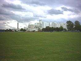
St Helier Hospital (full title: St Helier Hospital and Queen Mary's Hospital for Children) in the London Borough of Merton and London Borough of Sutton is run by Epsom and St Helier University Hospitals NHS Trust along with Epsom Hospital. It is located next to the large St Helier council estate and close to the major intersection known as Rosehill.
The hospital offers a full range of hospital services including a 24-hour accident and emergency department. The site is also home to the South West Renal and Transplantation Service and the Queen Mary's Hospital for Children, a dedicated children's hospital. St Helier Hospital is a major teaching hospital for St George's, University of London, and is the second main teaching site for the clinical years of the medicine degrees outside of St George's Hospital.
As part of the Better Services Better Value Review of NHS services in London it was proposed to downgrade the maternity and Accident and Emergency Departments. However, it appeared in December 2013 that at least some local GPs were not in favour of this.[1]
Description of the site


The site is located on the B278 (Wrythe Lane) opposite St Helier Open Space. It is approximately 2 miles from Sutton, 5 miles from Croydon and 10 miles from Central London. It is close to the Rosehill Roundabout which is the junction for the A217 and A297.
The main entrance leads into B block (see below). Just to the right of the main entrance is the entrance to the accident and emergency department. St Helier Hospital comprises 6 buildings, all of which are accessible from the outside of the hospital (as each has its own entrance) as well as via link corridors via the main building.
The main building is divided into three blocks: A, B and C. The names of the wards and operating theatres are based on their location in the hospital - a ward located on, say, the fifth floor of B block is labelled B5 ward.
The other buildings are:
- The pathology block (labelled D) which also contains the genitourinary medicine clinic.
- The Women's Health Block (which contains the maternity and gynaecology wards, gynaecology clinics and delivery suite).
- The renal block
- Queen Mary's Hospital for Children
- Ferguson House (contains some outpatient clinics, administration departments and undergraduate teaching suite).
The Women's Health Block, Renal Unit and Queen Mary's are connected to the main building via an underground tunnel from the Ground Floor of B block. D block is connected via the first floor of C block and Ferguson House via the first floor of A block (although the link is on the Ground Floor of Ferguson House - there is a ramp down from the main hospital to Ferguson House).
Transport links
The hospital is accessible by bus, however although many buses stop at Rose Hill Roundabout (which is about 5 minutes walk from the hospital) only a few buses actually stop outside the hospital. The nearest Underground station is Morden, from which there are frequent buses to Rose Hill and the hospital. The nearest National Rail station is St Helier which is 1,600 yards from the hospital (about a 15-minute walk), although this is infrequently served (only 1 train every 30 minutes off peak). There is a more frequent National Rail service to either Carshalton (connect to the hospital by bus) or Sutton (which has very frequent buses to Rose Hill and outside the hospital). Some of the buses that stop outside the hospital are the 151, 157 and the S1.
Name and history
Helier was a 6th-century saint invoked as a healing saint for diseases of the skin and eyes, who lived in Northern France and the Channel Islands.
The hospital derives its name from the surrounding area of council housing, built between 1926 and 1938, and named to honour Mary Jeune, Baroness St Helier who was a prominent alderman on the London County Council.

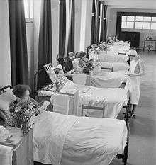
In 1934 Surrey County Council acquired a 999-year lease of 10 acres of the St Helier housing estate to build a hospital .The architects were Saxon Snell & Phillips who were chosen for their experience in hospital design.[2] The architectural style is Thirties modernism. Construction was started in 1938 at a stone laying ceremony attended by Queen Mary. It received its first patients on 24 February 1941 during World War Two . Less than a month later, the hospital was damaged in a bombing raid by a parachute mine. The official opening was in 1942. Further damage was caused in later raids and the hospital was struck by two flying bombs in June 1944.[3] St Helier remained functional throughout the War and was painted green to make it less visible to German bombers. [4] During the hospital's Jubilee year in 1963, the Queen Mother visited the hospital. In 1987, Diana Princess of Wales officially opened the new £2m maternity unit.
In 1999, it was joined with three other local hospitals, Epsom, Sutton and Queen Mary's Hospital for Children, to form the Epsom and St Helier University Hospitals NHS Trust.
The conservative MP John Major, who was Prime Minister between 1990 and 1997 was born at St Helier Hospital in 1943.[5]
See also
References
- ↑ "GPs vote against closure of local A&E". Pulse. 2 December 2013. Retrieved 2 December 2013.
- ↑ Hyatt, Christine. "A Brief History of St. Helier Hospital". Sutton Local Records and Archives, London Borough of Sutton.
- ↑ Roberts, Zoe (2010-05-07). "History of St.Helier Hospital The first Foundation stone". Sutton Local Records and Archives, London Borough of Sutton.
- ↑ "Epsom and St Helier NHS trust - Our Story". St Helier Hospital. Epsom and St Helier University Hospitals. Retrieved 11 Aug 2015.
- ↑ There is a plaque at the main entrance of the hospital stating this.
Further reading
- Peacock, D. Two O'Clock at the Gate: A Nurses Training During the Fifties. Victoria, BC: Trafford, 2008. ISBN 1-4251-6249-5.
External links
| Wikimedia Commons has media related to St Helier Hospital. |
Coordinates: 51°22′49″N 0°11′01″W / 51.3803°N 0.1836°W