Spenge
| Spenge | ||
|---|---|---|
| ||
 Spenge | ||
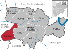
Location of Spenge within Herford district 
 | ||
| Coordinates: 52°07′59″N 08°28′59″E / 52.13306°N 8.48306°ECoordinates: 52°07′59″N 08°28′59″E / 52.13306°N 8.48306°E | ||
| Country | Germany | |
| State | North Rhine-Westphalia | |
| Admin. region | Detmold | |
| District | Herford | |
| Government | ||
| • Mayor | Bernd Dumcke (SPD) | |
| Area | ||
| • Total | 40.244 km2 (15.538 sq mi) | |
| Population (2015-12-31)[1] | ||
| • Total | 14,768 | |
| • Density | 370/km2 (950/sq mi) | |
| Time zone | CET/CEST (UTC+1/+2) | |
| Postal codes | 32139 | |
| Dialling codes |
05225 05223 (northeast), 05428 (far west), 05206 (south, esp. Nagelsholz) | |
| Vehicle registration | HF | |
| Website | www.spenge.de | |
Spenge is a town in the district of Herford, in North Rhine-Westphalia, Germany
Geography
Spenge is situated north of Bielefeld and west of Herford. It borders Lower Saxony in the west.
Subdivisions
Spenge consists of 5 subdivisions (population as of December 31, 2001):
- Bardüttingdorf (1,480 inhabitants)
- Hücker-Aschen (1,465 inhabitants)
- Lenzinghausen (2,793 inhabitants)
- Spenge (8,696 inhabitants)
- Wallenbrück (1,976 inhabitants)
Towns and local subdistricts
|
|
|
|
|
Notable places
- Lutheran Church of Sankt Martin built in the 13th Century, within the Altar of St. Martin, created around 1470.
 Lutheran Church of Sankt Martin in Spenge as of March 2006
 in 2005 rebuilt Wegscheider-Organ in the Church of Sankt Martin in Spenge as of March 2006
- Marienkirche in Wallenbrück built 1096, to the west of Spenge
- Mühlenburg Castle built in 1468.
 Gate to Schloss Mühlenburg in July 2004
 Coat of arms at gate to Schloss Mühlenburg
Sons and daughters of the town
- Eberhard Werdin (1911-1991), composer and music pedagogue
- Friedrich-Wilhelm Graefe zu Baringdorf (born 1942), politician (Alliance '90 / The Greens), 1984-1987 and 1989-2009 Member of the European parliament
References
- ↑ "Amtliche Bevölkerungszahlen". Landesbetrieb Information und Technik NRW (in German). 18 July 2016.
External links
| Wikimedia Commons has media related to Spenge. |
- Official site (German)
This article is issued from Wikipedia - version of the 12/1/2016. The text is available under the Creative Commons Attribution/Share Alike but additional terms may apply for the media files.
