Skalkaho Pass
| Skalkaho Pass | |
|---|---|
|
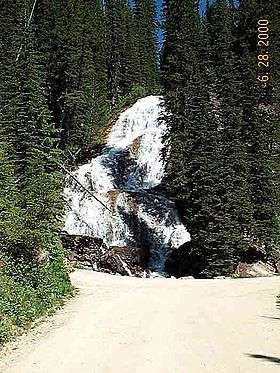
Skalkaho Falls near the head of the pass. | |
| Elevation | 7,258 ft (2,212 m) |
| Traversed by |
|
| Location | Ravalli County, Montana, United States |
| Range | Sapphire Mountains |
| Coordinates | 46°14′45″N 113°46′24″W / 46.2457°N 113.7734°WCoordinates: 46°14′45″N 113°46′24″W / 46.2457°N 113.7734°W |
| Topo map | USGS Skalkaho Pass |
The Skalkaho Pass (Salish: Sq̓x̣q̓x̣ó, "many trails" [1]), 7,258 feet (2,212 m) above sea level,[2] is a pass in the Sapphire Mountains in southwest Montana traversed by Montana Highway 38.[3]
The road over the pass connects the towns of Hamilton in the Bitterroot Valley and Philipsburg in Flint Creek Valley and remains the only direct route between these two important agricultural areas. Originally an Indian route, Highway 38 was built in 1924 to link mountainous mining areas with the agricultural settlements in the valleys.[3][4] The route is closed during winter due to heavy snowfall.
Skalkaho Falls (46°15′28″N 113°49′36″W / 46.2577°N 113.8268°W) is near the top of the pass.
See also
References
- ↑ "Salish Audio Files". Salish-Pend d'Oreille Culture Committee. 2014. Retrieved 2014-06-28.
- ↑ Federal Writers' Project Montana, Montana: A State Guide Book pub. US History Publishers, 1939 ISBN 1-60354-025-3 p. 303
- 1 2 "Skalkaho Pass". Montana, Official State Travel Site. Retrieved 2013-10-02.
- ↑ Skalkaho Pass & Wildlife Area
- "Skalkaho Pass". Geographic Names Information System. United States Geological Survey. Retrieved 2009-05-31.
External links
- "The Skalkaho Highway Scenic Byway in Southwest Montana : Information, Photos and Maps".
- Going over Skalkaho Pass ... Anaconda to Hamilton, Montana, YouTube
This article is issued from Wikipedia - version of the 11/30/2016. The text is available under the Creative Commons Attribution/Share Alike but additional terms may apply for the media files.
