Shantar Islands National Park
| Shantar Islands National Park | |
|---|---|
| Russian: Шантарские острова | |
|
IUCN category II (national park) | |
|
Bowhead whales in Lingholm Strait | |
 Location of Park | |
| Location | Khabarovsk Krai |
| Nearest city | Chumikan |
| Coordinates | 55°00′N 137°30′E / 55.000°N 137.500°ECoordinates: 55°00′N 137°30′E / 55.000°N 137.500°E |
| Area | 515,500 hectares (1,273,828 acres; 5,155 km2; 1,990 sq mi) (274,484 hectares of which is marine) |
| Established | 2013 |
| Governing body | FGBU "Shantar Islands" |
Shantar Islands National Park (Russian: Шантарские острова (национальный парк)) covers both the terrestrial and maritime surroundings of the Shantar Islands, a group of 15 currently uninhabited islands that lie close to the coast of Khabarovsk Krai, in the Sea of Okhotsk in the Russian Far East. Most of the islands are moderately mountainous, with rugged cliffs; the highest point is 720 m (2,375 ft). Situated just to the east of the westernmost, shallowest and calmest bay in the Sea of Okhotsk, the area around the islands is an important area for marine mammals - including Steller Sea Lions, seals, and many species of cetacean (gray, bowhead, minke, beluga, and killer whale) - plus spawning salmon and very large colonies of birds. The park was formerly a state nature reserve (established in 1999), but re-established as a federal national park in 2013 with the stated purpose of protecting the habitat of vulnerable species (and in particular guarding against poaching), and supporting the scientific study and ecological tourism of the area. The Shantar Islands are located in the Tuguro-Chumikansky District of Khabarovsk Krai. The park is overseen by the Russian Ministry of Natural Resources. [1]
Topography

The Shantar Islands lie on the eastern side of Uda Gulf; until 9,000-10,000 years ago they were connected, which explains why there the floral ecosytem of the island contains no endemic species. Of the 15 islands and many rocks that rise above the surface, two make up 75% of the terrestrial area of the park: Bolshoy Shantar Island (176,600 hectares (436,000 acres), or 30x45 miles in size), and Feklistova Island (37,200 hectares (92,000 acres)) which is about 20 km (12 mi) west of Bolshoy Shantar. Uda Gulf separates the main islands from the coast to the west. Tides reach 5 - 8 m (16.5 - 26.2 ft), and currents around the island are very strong. Fog is frequent.[2]
Climate and ecoregion
The climate of Shantar Islands is more severe than that of the Okhotsk Sea in general. The prevailing northeast winds push ice floes into the coast around Shantar, leaving only 2-3 months per year of ice-free water.[2] The official climate designation for the Shantar area is "Subarctic climate" (Köppen climate classification Dwc), with long, cold winters and short cool summers.[3]
| Bolshoy Shantar Island (2014), (Russia) | ||||||||||||||||||||||||||||||||||||||||||||||||||||||||||||
|---|---|---|---|---|---|---|---|---|---|---|---|---|---|---|---|---|---|---|---|---|---|---|---|---|---|---|---|---|---|---|---|---|---|---|---|---|---|---|---|---|---|---|---|---|---|---|---|---|---|---|---|---|---|---|---|---|---|---|---|---|
| Climate chart (explanation) | ||||||||||||||||||||||||||||||||||||||||||||||||||||||||||||
| ||||||||||||||||||||||||||||||||||||||||||||||||||||||||||||
| ||||||||||||||||||||||||||||||||||||||||||||||||||||||||||||
The maritime ecoregion of Shantar Islands is "North Temperate Indo-Pacific / Sea of Okhotsk", (WWF Maritime Ecoregion #204), characterized by cool but fertile waters that support enormous fisheries and bird centers. Currents keep the areas near the coast cooler than areas to the east; the variety and proximity of temperature support the high levels of biodiveristy. [4]
Plants
The larger islands are covered with dark coniferous forests, primarily Siberian spruce, larch, cedar, and birch. There are no endemic plant species on the islands, as they are close to, and until relatively recently connected to, the mainland.
Animals
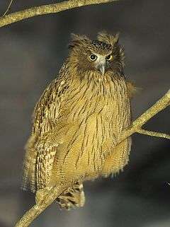
Park rules will protect the maritime environment, with fishing prohibited out to 1-3 miles from the coast to cover salmon spawning areas. Terrestrial mammals include brown bear, caribou, red fox, sable, river otter, and ringed seals. Over 240 species of birds live on or migrate through the Shantars, including the endangered species such as the Blakiston's fish owl and Steller's sea eagle.[5]
 Blakiston's fish owl,
the largest species of owl.jpg) Steller's sea eagle
Steller's sea eagle Bowhead whale showing head
 Bowhead whale tail-slapping
History
The islands have a long history of visits by humans for use as bases for fur trapping, whaling, fishing, and hunting. American whaleships hunted bowhead whales around the islands between 1852 and 1874.[6][7] Logging has occurred in past, and the islands are in a region with potential mineral reserves - all adding pressure on the site for economic use. The islands were set aside as a state nature reserve in 1999, and except for a meteorological station and occasional scientific camps, are now uninhabited.[8]
Tourism
The park is still being established, with rules, infrastructure and zoning being developed. Ecotourism, education, and scientific study are all stated in the plans for the territory. There are commercial tour groups operating in the area.
See also
References
- ↑ "Official Decree Creating Shantar Islands National Park" (in Russian). Russian Federation. Retrieved January 10, 2016.
- 1 2 "Shantar". Shantary. Retrieved January 10, 2016.
- ↑ "Climate Data, Kosh-Agach". climate-data.org.
- ↑ "Ecoregion - Sea of Okhotsk". World Wildlife Fund. Retrieved January 10, 2015.
- ↑ "Russia's Shantar Islands Permanently Protected". Wild Salmon Center. Retrieved January 10, 2016.
- ↑ Arctic, of Fairhaven, July-Oct. 1852. In Gelett, C. W. (1917). A life on the ocean: Autobiography of Captain Charles Wetherby Gelett. Honolulu, Hawaii: Hawaiian Gazette Co., Ltd.
- ↑ Harrison, of New Bedford, July 4-Sept. 11, 1853, Nicholson Whaling Collection (NWC); Sea Breeze, of New Bedford, July 16-Sept. 30, 1874, G. W. Blunt White Library (GBWL).
- ↑ "Proclamation of Shantar Islands State Nature Reserve, Khabarovsk Krai, 1999" (in Russian). Khabarovsk News. Retrieved January 10, 2016.
External links
- Old state government map of the islands, with notes regarding nesting and gathering sites.