Sanggamryong
This article is about a mountain pass. For the battle in the Korean War, see Battle of Triangle Hill. For the Chinese war film, see Battle on Shangganling Mountain.
| Sanggamryong | |
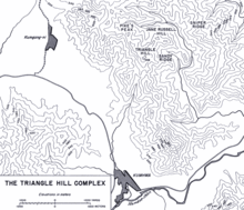
 Map of the Triangle Hill Complex, Sanggamryŏng is located at the Y junction behind Jane Russell Hill | |
| Korean name | |
|---|---|
| Chosŏn'gŭl | 상감령 |
| Hancha | 上甘嶺 |
| Revised Romanization | Sanggamryeong |
| McCune–Reischauer | Sanggamryŏng |
| Triangle Hill | |
| Hangul | 삼각고지 |
|---|---|
| Hanja | 三角高地 |
| Revised Romanization | Samgakgoji |
| McCune–Reischauer | Samgakkoji |
Sanggamryŏng, also known as Shangganling (Chinese: 上甘岭; pinyin: Shànggānlǐng) in Chinese, Triangle Hill (Korean: 3각고지) in South Korea, and Jane & Russell Hill in United States is a mountain pass in central North Korea.
The mountain pass is part of the Triangle Hill Complex that is roughly 4 km north by northeast of Kimhwa. Situated in the valley between the Jane Russell Hill and the Sniper Ridge, the hamlet became famous in China due to the Battle of Shangganling, a large-scale battle in the Korean War. By the time the fighting broke out, the hamlet had already been leveled by bombings with most of its residents displaced, thus it played no role in the battle itself.
References
- Zhou, Ming (周明) (2000). "Shangganling Campaign (上甘岭战役)". Endorsed by Chinese Academy of Social Sciences, War to Resist America and Aid Korea Research Net. Archived from the original on February 15, 2009. Retrieved 2009-02-04. External link in
|publisher=(help) - Chae, Han Kook; Chung, Suk Kyun; Yang, Yong Cho (2001), Yang, Hee Wan; Lim, Won Hyok; Sims, Thomas Lee; Sims, Laura Marie; Kim, Chong Gu; Millett, Allan R., eds., The Korean War, Volume III, Lincoln, NE: University of Nebraska Press, ISBN 978-0-8032-7795-3
Coordinates: 38°20′0″N 127°28′0″E / 38.33333°N 127.46667°E
This article is issued from Wikipedia - version of the 9/12/2016. The text is available under the Creative Commons Attribution/Share Alike but additional terms may apply for the media files.