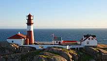
Ryvingen Lighthouse
 Ryvingen Lighthouse | |
 Vest-Agder | |
| Location |
Mandal Vest-Agder Norway |
|---|---|
| Coordinates | 57°58′05″N 7°29′30″E / 57.968170°N 7.491567°E |
| Year first constructed | 1867 |
| Automated | 2002 |
| Construction | cast iron tower |
| Tower shape | cylindrical tower with balcony and lantern |
| Markings / pattern | red tower with an horizontal white band, red lantern |
| Height | 22.5 metres (74 ft) |
| Focal height | 52 metres (171 ft) |
| Intensity | 996,500 cd |
| Range | 19.5 nmi (36.1 km; 22.4 mi) |
| Characteristic | Fl (4) W 40s. |
| Admiralty number | B3014 |
| NGA number | 1572 |
| ARLHS number | NOR-191 |
| Norway number | NF-0790 |
| Managing agent | Ryvingen fyrstasjon[1] |
Ryvingen Lighthouse (Norwegian: Ryvingen fyr) is a coastal lighthouse located on an island in the municipality of Mandal, Vest-Agder, Norway.
History
It was first lit in 1867, and is the southernmost lighthouse in Norway. The lighthouse was automated in 2002, and is listed as a protected site.[2][3]
See also
References
- ↑ Ryvingen Lighthouse The Lighthouse Directory. University of North Carolina at Chapel Hill. Retrieved March 8, 2016
- ↑ Godal, Anne Marit (ed.). "Ryvingen fyr". Store norske leksikon (in Norwegian). Oslo: Norsk nettleksikon. Retrieved 6 April 2012.
- ↑ "Ryvingen fyrstasjon" (in Norwegian). Norsk Fyrhistorisk Forening. Retrieved 6 April 2012.
- Rowlett, Russ. "Lighthouses of Norway: Kristiansand Area". The Lighthouse Directory. University of North Carolina at Chapel Hill.
External links
- Norsk Fyrhistorisk Forening (Norwegian)
| Wikimedia Commons has media related to Ryvingen fyr. |
Coordinates: 57°58′05.4″N 7°29′29.7″E / 57.968167°N 7.491583°E
This article is issued from Wikipedia - version of the 3/8/2016. The text is available under the Creative Commons Attribution/Share Alike but additional terms may apply for the media files.