Roker Park (park)
Coordinates: 54°55′31.47″N 1°22′9.63″W / 54.9254083°N 1.3693417°W / 54.9254083; -1.3693417
For the former stadium of the same name, see
Roker Park.
| Roker Park |
|---|
| Type |
Municipal |
|---|
| Location |
Sunderland, United Kingdom |
|---|
| Created |
1880 |
|---|
| Operated by |
Sunderland City Council |
|---|
| Status |
Open all year |
|---|
Roker Park is a recreation park in the Roker area of Sunderland, Tyne and Wear, England.
The land on which the park stands was donated by Sir Hedworth Williamson, 8th Baronet and the Church Commissioners, and opened on 23 June 1880.[1] The park is roughly an upside down reversed 'L' shape. It is bounded by Park Parade to the south, Roker Park Terrace to the east, Roker Park Road to the west and Side Cliff Road to the north. The northern part of the park is the widest and fronts onto Roker beach via a ravine, which passes under a wooden footbridge. In the centre of the park is a large freeform boating lake which is used for remote-controlled model boating. In the northwest corner of the park is a model narrow gauge railtrack which was built in the 1970s. There are two bowling greens as well as tennis and multi-purpose sports courts.
Listed buildings
Bandstand

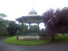
The bandstand.
The park's bandstand is octagonal, cast-iron with a wood base and a metal-covered roof.[2]
Drinking fountain
The memorial drinking fountain in the park commemorates Sir Hedworth's gift of land for Roker Park. It is made of ashlar, sandstone and granite and was erected by 'scholars, teachers and friends of Sunday Schools in Sunderland to commemorate the celebration of the centenary of Sunday Schools and the opening of Roker Park June 23 1880.'[3]
Sunderland Illuminations
Sunderland Illuminations light up Roker Park and Seaburn from September until Sunday November.
Gallery
-
The bridge carrying the A183 coast road over Roker Park Ravine.
-
References
|
|---|
|
| | | | Grade II |
|---|
| | Sunderland | | City Centre |
- Sunderland Museum
- St Mary's Church
- Mowbray Almshouses
- Sunderland County Court
- Corder House and Sydenham House
- Elephant Tea Rooms
- Green's Public House
- The Isis
- Sunderland Gas Board
- Galen Building
- Fitzgerald's Public House
- Wearmouth Bridge
- River Wear Commission Building
- St Mary's Building
- Wearmouth Rail Bridge
- Sunderland Magistrates' Court
- Hawksley House
- Victoria Hall Disaster Memorial
- Sunderland War Memorial
- Burdon Road Masonic Temple
- 4–25 Foyle Street
- 28–40 and 43–48 West Sunnside
- Medieval Arch & Wall
- Central Buildings
- Former General Post Office
- Former Custom House
- Maritime Buildings
- 19, 20, 29 and 30 Villiers Street
- West Park Church
- 17–29, 32–42 & 45–58 Frederick Street
- Mowbray Park (certain buildings)
- Midland Bank
- National Westminster Bank
- Barclays Bank
- Lloyds Bank
- 11–17, 20–23 25–28 and 45–58 John Street
- 2 & 3 Mary Street
- 3–5 Albion Place
- 19 & 31–33 Norfolk Street
- 3 & 22 Athenaeum Street
- Hutchinson's Buildings
- The Londonderry
- The Dun Cow
- 1–7, 105–112, 114–118, 145, 170–173, 176, 211, 212 and 214–217 High Street West
- 49–51 High Street East
|
|---|
| Monkwearmouth
and Southwick | |
|---|
| Ryhope
and Burdon | |
|---|
| Ashbrooke
and Thornholme |
- Bede Tower
- Sunderland Synagogue
- Christ Church
- West Hendon House
- St John's Church
- Carlton House
- Langham Tower
- Ashburne House
- The Crofts
- Gray House
- St George's House
- 3–7 Douro Terrace
- Valebrooke Gardens
- Westburn House
- 1–29 Thornhill Terrace
- 1–15 Grange Crescent
- 1–9 The Esplanade
- Burdon House
- 1–16 St Bede's Terrace
- 1–24 Park Place East and West
- Park Road Methodist Church
|
|---|
| Hendon
and Grangetown |
- Hendon Gas Works
- Quayside Exchange
- St Aidan's Church
- Trafalgar Square Merchant Seaman's Almshouses
- St Ignatius Church
- Tavistock House
- Sunderland Orphanage
- 10 Church Street East
- Salisbury Street Steps
- Sunderland Cemetery (certain buildings)
- Former Methodist Manse
- Bethesda Free Church
- 17–23 Murton Street
- 3–19 Ridley Terrace
- North Dock (walls and mooring posts)
- Hudson Dock (certain buildings)
- Sunderland Harbour South Pier
- Whylam Wharf
- Bonded Warehouse
|
|---|
| Barnes
and Humbledon |
- Barnes School
- St Gabriel's Church
- Kayll Road Library
- Children's Hospital
- Humbledon Pumping Station
- Hill House
- Bishopwearmouth Cemetery (certain buildings)
- Barnes Park Bandstand
|
|---|
| Deptford, Millfield
and Pallion | |
|---|
| Silksworth
and Tunstall |
- Silksworth Hall
- Tunstall Lodge
- Silksworth Cottage
- Tunstall School
- Tunstall Hope Lodge
|
|---|
| North Hylton
and South Hylton | |
|---|
| Fulwell, Roker
and Whitburn Bents | |
|---|
| Middle and
East Herrington | |
|---|
|
|---|
| | Washington |
- Blue House Villa
- 'F' Pit
- The Old Hall Smithy
- Low Barmston Farmhouse
- Red Hill House
- Usworth Hall
- Fatfield House
- Our Blessed Lady Immaculate Church, Washington
- Certain buildings in/on: Peareth Hall Road
- The Avenue
|
|---|
| | Houghton-le-Spring | | Houghton-le-Spring |
- Davenport and Lilburne Almshouses
- Lilburn House
- Gilpin House
- The Villa
- The Rectory
- St Michael's Church
- The Old Mill
- Laburnum House
- Houghton Mines Rescue Station
- High Farm House
- St Cuthbert's Church
- Stoneygate Pumping Station
- Philadelphia Power Station
- Certain buildings in/on: Nesham Place
- Front Street, Newbottle
- Philadelphia Lane
|
|---|
| | Hetton-le-Hole |
- St Nicholas' Church, Hetton-le-Hole
- St Nicholas House
- Easington Lane War Memorial
- Pithead Baths
- Smithy
- Primitive Methodist Church
|
|---|
| | Newbottle |
- Russell House
- Newbottle Working Men's Club
- St Matthew's Church, Newbottle
- Cellar Hill House
|
|---|
| | Penshaw |
- All Saints' Church
- Penshaw House
- Alice Well
- Accommodation Arch
- Boundary Stone
|
|---|
|
|---|
|
|


