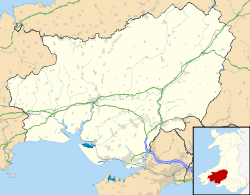
Rhosydd Llanpumsaint
| Site of Special Scientific Interest | |
 Location within Carmarthenshire | |
| Area of Search | Carmarthenshire |
|---|---|
| Grid reference | SN423276 |
| Coordinates | 51°55′27″N 4°17′42″W / 51.92406°N 4.29494°WCoordinates: 51°55′27″N 4°17′42″W / 51.92406°N 4.29494°W |
| Area | 39.4 hectares (0.3940 km2; 0.1521 sq mi) |
| Notification | 12 February 2010 |
Rhosydd Llanpumsaint is a Site of Special Scientific Interest (SSSI) in Carmarthenshire, Wales.[1][2]
SSSI
Rhosydd Llanpumsaint SSSI is located approximately 1.33 miles (2.14 km) west-sout-west of Pontarsais and 1.33 miles (2.14 km) north-west of Rhydargaeau. The site covers 39.4 hectares (97 acres).[1][2]
The Rhosydd Llanpumsaint site is notable for geomorphological features which in turn support special biological features. The site - field and peatland - has on its west side numerous oval depressions of up to 70 metres (230 ft) diameter thought to have been formed by mineral pillers under permafrost ice which have collapsed on the retreat of the ice, to leave an undulating surface the depressions of which have become sediment and peat filled. The site is one of the best exampes of ramparted ground-ice depression features in Wales. The depressions, in turn, provide a mire habitat for a variety of plants such as red bog moss (Sphagnum capillifolium), hare's-tail cotton-grass (Eriophorum vaginatum), cross-leaved heath (Erica tetralix) and heather (Calluna vulgaris). The mix of plants in any depression varies according to conditions in and water supply for the depression, and the site hosts a wide and diverse set of species including the only known colony of the liverwort (Pallavicinia lyellii) in Carmarthenshire.[2]
See also
References
- 1 2 "MAGIC Map Application". DEFRA MAGIC Map. DEFRA.
- 1 2 3 "Site of Special Scientific Interest, Carmarthenshire, Rhosydd Llanpumsaint" (PDF). Natural Resources Wales.
External links
- SSSI Citation for Rhosydd Llanpumsaint
- Citation map for Rhosydd Llanpumsaint
- Your Special Site and its Future - Rhosydd Llanpumsaint SSSI overview from Natural Resources Wales
- Rhosydd Llanpumsaint SSSI marked on DEFRA's MAGIC Map