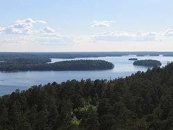
Pyhäjärvi (Tampere region)
| Lake Pyhäjärvi | |
|---|---|
 | |
| Location | Pirkanmaa, Finland |
| Coordinates | 61°29′N 023°40′E / 61.483°N 23.667°ECoordinates: 61°29′N 023°40′E / 61.483°N 23.667°E |
| Primary inflows | Tammerkoski |
| Primary outflows | Nokianvirta |
| Basin countries | Finland |
| Surface area | 121.61 km2 (46.95 sq mi)[1] |
| Max. depth | 46 m (151 ft) |
| Surface elevation | 77.2 m (253 ft)[1] |
| Settlements | Tampere, Nokia, Lempäälä |
| References | [1] |
Pyhäjärvi is a lake in southern Finland. Although the name means in modern Finnish "holy lake", it probably meant originally "border lake". Pyhäjärvi is shaped like the letter "C" with the cities of Tampere and Nokia on the northern end, and town of Lempäälä at the southern end.
The lake is fed by the water running through the Tammerkoski rapids in the center of Tampere from the North, and by the waters from lake Vanajavesi in the South. Because of the Tammerkoski rapids, the water in Pyhäjärvi is warmer and richer in ozone than that in the northern lake, Näsijärvi, which results in the life in this lake being richer, even though the water is more polluted.
There are a number of other Pyhäjärvis in Finland and its former territories, as well.
Viikinsaari is an island meaning Viking Island that is found in Pyhäjärvi. On it are held various summer events. There is a church in which can be seen old pagan symbols and a door marked with fist marks. The fist prints were left by the desperate red women that were imprisoned there before being led out and massacred during the Finnish civil war, which was between the Reds and Whites.
During the summer there are regular trips from Tampere's Vieras Satama (Unknown boat Harbour) by pleasure boat to the Island. There is also a dance hall and restaurant there.
References
External links
![]() Media related to Pyhäjärvi Lake (Tampere) at Wikimedia Commons
Media related to Pyhäjärvi Lake (Tampere) at Wikimedia Commons