Parzymiechy
| Parzymiechy | |
|---|---|
| Village | |
 Parzymiechy | |
| Coordinates: 51°2′N 18°44′E / 51.033°N 18.733°E | |
| Country |
|
| Voivodeship | Silesian |
| County | Kłobuck |
| Gmina | Lipie |
| Highest elevation | 256.8 m (842.5 ft) |
| Lowest elevation | 219.0 m (718.5 ft) |
| Population | 715 |

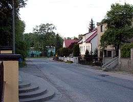
Central part of the village

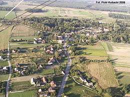
Parzymiechy from a bird
Parzymiechy [paʐɨˈmjɛxɨ] is a village in the administrative district of Gmina Lipie, within Kłobuck County, Silesian Voivodeship, in southern Poland.[1] It lies approximately 6 kilometres (4 mi) north-west of Lipie, 20 km (12 mi) north-west of Kłobuck, and 89 km (55 mi) north of the regional capital Katowice.
The village has a population of 715.
History
Parzymiechy was first mentioned in 1266.
Transport
Main road connections from the Parzymiechy include connection with Praszka (to the west) and Działoszyn (to the north-east) via the National Road ![]() .
.
External links
References
Coordinates: 51°2′N 18°44′E / 51.033°N 18.733°E
This article is issued from Wikipedia - version of the 3/10/2013. The text is available under the Creative Commons Attribution/Share Alike but additional terms may apply for the media files.