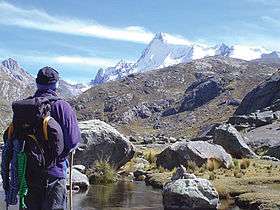
Pariacaca mountain range
| Pariacaca mountain range | |
|---|---|
| Waruchiri mountain range | |
 Pariacaca, south peak | |
| Highest point | |
| Peak | Paryaqaqa |
| Elevation | 5,750 m (18,860 ft) |
| Geography | |
| Country | Peru |
| State/Province | Junín Region, Lima Region |
| Parent range | Andes |
The Pariacaca mountain range (Quechua parya reddish, sparrow, qaqa rock,[1][2] Paryaqaqa or Parya Qaqa, a regional deity, a mountain god (apu),[3] hispanicized spellings Pariacaca, Pariacacca, Pariaccaca, Pariaccacca) or Waruchiri mountain range[4][2] (hispanicized Huarochirí) lies in the Andes of Peru. It is located in the Junín Region, in the provinces of Jauja and Yauli, and in the Lima Region, in the provinces of Huarochirí and Yauyos. It is part of the Cordillera Central (Spanish for "central range") of Peru.[5][6]
Mountains
The highest mountain in the range is Pariacaca (Tulluqutu) at 5,750 metres (18,865 ft). Other peaks are listed below:[7][8]
- Tunshu, 5,660 m (18,570 ft)
- Qullqi P'ukru, 5,658 m (18,563 ft)
- Qarwachuku, 5,507 m (18,068 ft)
- Paka, 5,500 m (18,000 ft)
- Suyruqucha, 5,500 m (18,000 ft)
- Wallakancha, 5,500 m (18,000 ft)
- Antashayri, 5,400 m (17,700 ft)
- Nina Ukru, 5,400 m (17,700 ft)
- Pachanqutu, 5,400 m (17,700 ft)
- Paqcha, 5,400 m (17,700 ft)
- Wayllakancha, 5,400 m (17,700 ft)
- Kunkus Yantaq, 5,354 m (17,566 ft)
- Wararayuq, 5,354 m (17,566 ft)
- Tuku Mach'ay, 5,350 m (17,550 ft)
- Putka, 5,300 m (17,400 ft)
- Qayqu, 5,300 m (17,400 ft)
- Tata Qayqu, 5,300 m (17,400 ft)
- Yantayuq, 5,300 m (17,400 ft)
- Chumpi, 5,250 m (17,220 ft)
- Ch'uspi, 5,200 m (17,100 ft)
- Quriwasi, 5,200 m (17,100 ft)
- Uqhu, 5,200 m (17,100 ft)
- Ukhu Qhata, 5,200 m (17,100 ft)
- Wiqu, 5,200 m (17,100 ft)
- Wamanripa, 5,110 m (16,770 ft)
- Kiwyu Waqanan, 5,100 m (16,700 ft)
- Qayqu, 5,100 m (16,700 ft)
- Chhuqu P'ukru, 5,000 m (16,000 ft)
- Parya Chaka, 5,000 m (16,000 ft)
- Kunkus, 5,000 m (16,000 ft)
- Kunkus (Yauli), 5,000 m (16,000 ft)
- Suyuq, 5,000 m (16,000 ft)
- Turiyuq, 5,000 m (16,000 ft)
- Uqsha Wallqa, 5,000 m (16,000 ft)
- Wallapi, 4,800 m (15,700 ft)
References
- ↑ César W. Astuhuamán Gonzáles, Pariacaca: un oráculo imperial andino: "Respecto al significado del nombre de la deidad, los términos Paria (rojiza) y caca (montaña), aluden a una montaña rojiza, ... ."
- 1 2 Teofilo Laime Ajacopa, Diccionario Bilingüe Iskay simipi yuyayk'ancha, La Paz, 2007 (Quechua-Spanish dictionary)
- ↑ Steven Kaplan, Indigenous Responses to Western Christianity, New York and London, 1995, p. 68-69
- ↑ Evelio Echevarría, The Cordillera Huarochiri, Peru, The Alpine Journal 2001: "Names used by mountaineers other than Huarochiri and Pariacacca are unknown to the local inhabitants and should therefore be discarded. ... The best policy is to refer to this range with either of the names in use by the local population."
- ↑ Inventario de Glaciares del Perú, Ministerio de Agricultura y Riego, Autoridad Nacional del Agua, Huaraz 2014
- ↑ Benjamín Morales Arnao, Glaciers of South America, Glaciers of Peru U.S. Geological Survey Professional Paper 1386-I-4
- ↑ allthemountains.com Maps of the Central Andes of Peru including two maps of the Paryaqaqa mountain range (inactive website)
- ↑ escale.minedu.gob.pe - UGEL map of the Yauli Province (Junín Region) and the Huarochiri Province (Lima Region)
External links
| Wikimedia Commons has media related to Paryaqaqa. |
This article is issued from Wikipedia - version of the 8/28/2016. The text is available under the Creative Commons Attribution/Share Alike but additional terms may apply for the media files.