Pagami Creek Fire
| Pagami Creek Fire | |
|---|---|
|
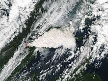
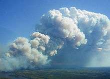
Smoke rises from the fire. | |
| Location | Northern Minnesota |
| Coordinates | 47°51′18″N 91°20′05″W / 47.855°N 91.334722°W |
| Statistics[1] | |
| Date(s) | August 18, 2011 – November 2011 |
| Burned area | 92,682 acres (375 km2) |
| Cause | Lightning |
| Map | |
 Location of fire in Minnesota | |

Pagami Creek smoke plume
The Pagami Creek Fire was a wildfire in Northern Minnesota, United States, that began with a lightning strike on August 18, 2011.[1] After weeks of slow growth, the wildfire quickly spread to over 92,000 acres (370 km2) during several days of hot, dry, windy weather in mid-September.[2] The fire spread beyond the Boundary Waters Canoe Area Wilderness to threaten homes and businesses.[3] Smoke from the fires drifted east and south as far as the Upper Peninsula of Michigan, Ontario, Chicago, Poland, Ukraine, and Russia.[4]
References
| Wikimedia Commons has media related to Pagami Creek Fire. |
- 1 2 "Pagami Creek Fire". InciWeb: Incident Information System. 22 October 2011. Archived from the original on 4 November 2011.
- ↑ Pagami Creek Wildfire (PDF), Superior National Forest, December 2011, retrieved 2012-01-15
- ↑ Douglas Etten (2011-09-13). "Boundary Waters fire threatening homes, cabins". Lakeland Times. Retrieved 2011-09-13.
- ↑ "Ont. smells smoke from Minnesota forest fire". CTV Toronto. 2011-09-13. Retrieved 2011-09-13.
This article is issued from Wikipedia - version of the 9/11/2016. The text is available under the Creative Commons Attribution/Share Alike but additional terms may apply for the media files.
