Oued Saoura
| Oued Saoura | |
|---|---|
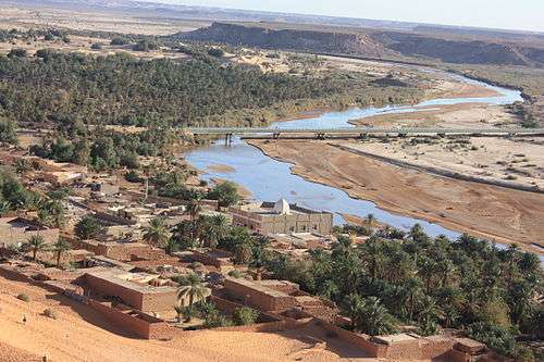 The Oued Saoura at Béni Abbès | |
| Country | Algeria |
| Basin | |
| Main source | Confluence of Oued Guir and Oued Zouzfana |
| River mouth |
Sebkhel el Melah 300 m (980 ft) |
| Features | |
| Tributaries |
|
Oued Saoura is an intermittent river, or wadi, formed from the confluence of the Oued Guir and Oued Zouzfana at Igli, forming the Saoura valley.[1] While in the past the flow of the river was steady and plentiful, in recent years it has diminished due to the construction of the Djorf Torba dam on the Oued Guir.[1]
Course
From Igli the Oued Saoura runs through Béchar Province past the towns of Béni Abbès, Tamtert, El Ouata, Béni Ikhlef, Kerzaz, Timoudi, Ouled Khoudir, and Ksabi, then passes under the N6 highway before reaching the endorheic lake Sebkha el Melah.
Coordinates: 30°29′11″N 2°18′18″W / 30.48639°N 2.30500°W
References
- 1 2 Merzougui, Touhami. "L'eau dans l'oasis de Béni Abbés : un patrimoine essentiel (Vallée de la Saoura, Sud Ouest algérien)" (PDF). Nature Vivante. Retrieved 21 February 2013.
This article is issued from Wikipedia - version of the 6/20/2016. The text is available under the Creative Commons Attribution/Share Alike but additional terms may apply for the media files.