Ohio State Route 325
| ||||
|---|---|---|---|---|
 | ||||
| Route information | ||||
| Maintained by ODOT | ||||
| Length: | 24.10 mi[1] (38.79 km) | |||
| Existed: | 1932 – present | |||
| Major junctions | ||||
| South end: |
| |||
|
| ||||
| North end: |
| |||
| Location | ||||
| Counties: | Gallia, Meigs | |||
| Highway system | ||||
| ||||
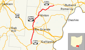
State Route 325 (SR 325) is a north–south state highway in the southeastern corner of the U.S. state of Ohio. The southern terminus of SR 325 is at SR 141 about 6 miles (9.7 km) south of Rio Grande. Its northern terminus is at a T-intersection with SR 124 approximately 5 miles (8.0 km) west of the village of Rutland.
Route description
The path of SR 325 takes it through the counties of Gallia and Meigs. No stretch of this highway is included as a part of the National Highway System, a network of routes that are considered most important for the nation's economy, mobility and defense.[2]
History
SR 325 was designated in 1932. Originally, the highway was routed between its current southern terminus at SR 141 and the current SR 588 junction in Rio Grande, which at the time was designated as State Route 11, the predecessor to US 35.[3][4] In 1937, SR 325 was extended northerly and easterly to its current northern terminus at SR 124.[5][6]
Major intersections
| County | Location | mi[1] | km | Destinations | Notes |
|---|---|---|---|---|---|
| Gallia | Perry Township | 0.00 | 0.00 | ||
| Rio Grande | 6.77 | 10.90 | Western terminus of SR 588 | ||
| Raccoon Township | 7.04 | 11.33 | Interchange | ||
| 7.19 | 11.57 | Western terminus of SR 554 | |||
| Vinton | 14.18 | 22.82 | Southern end of SR 160 concurrency | ||
| 14.42 | 23.21 | Northern end of SR 160 concurrency | |||
| Meigs | Salem Township | 24.10 | 38.79 | ||
1.000 mi = 1.609 km; 1.000 km = 0.621 mi
| |||||
References
- 1 2 Ohio Department of Transportation. "Technical Services Straight Line Diagrams". Retrieved 2010-12-11.
- ↑ National Highway System: Ohio (PDF) (Map). Federal Highway Administration. December 2003. Retrieved 2010-12-10.
- ↑ Ohio State Map (Map). Ohio Department of Transportation. 1932.
- ↑ Ohio State Map (Map). Ohio Department of Transportation. 1933.
- ↑ Ohio State Map (Map). Ohio Department of Transportation. 1936.
- ↑ Ohio State Map (Map). Ohio Department of Transportation. 1937.
