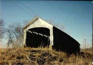
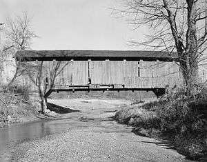
Nevins Covered Bridge
| Nevins Covered Bridge | |
| National Register of Historic Places | |
 Nevins Covered Bridge | |
| Official name: Nevins Covered Bridge | |
| Named for: Thomas Levi Nevins | |
| Country | |
|---|---|
| State | |
| County | Parke |
| Township | Raccoon |
| Road | C.R. 130E |
| Crosses | Little Raccoon Creek |
| Coordinates | 39°41′4.82″N 87°12′44.43″W / 39.6846722°N 87.2123417°WCoordinates: 39°41′4.82″N 87°12′44.43″W / 39.6846722°N 87.2123417°W |
| Length | 169 ft (52 m) 155ft +7ft overhangs on each end |
| Width | 16 ft (5 m) |
| Clearance | 13 ft (4 m) |
| Builder | Britton, J.A. |
| Design | Burr Arch truss single-span bridge |
| Material | Wood |
| Built | 1920 Original Cost $11,987 |
| Owned and Maintained by | Parke County |
| NBI Number | 6100028[1] |
| WGCB Number | #14-61-05[2] |
| Added to NRHP | Dec 22, 1978 |
| NRHP Ref# | 78000406 [3] |
| MPS | Parke County Covered Bridges TR |
|
Location of the Nevins Bridge in Indiana | |
 Location of Indiana in the United States | |
The Nevins Covered Bridge is a single span Burr Arch Truss covered bridge that crosses Little Raccoon Creek on County Road 130 East, just southeast of Catlin, Indiana. It was built in 1920 by Joseph A. Britton and Son.[4] Prior to the reconstruction of the Bridgeton Bridge in 2006, the Nevins Bridge was the newest covered bridge in Parke County.[5]
It was added to the National Register of Historic Places in 1978.[3]
History
The bridge was built at Gilkerson's Ford. Thomes Gilkerson had moved to the area in 1821 from Mercer County, Kentucky. In 1823 he built a mill near the ford that would later bear his name. The Gilkersons worked as blacksmiths, carpenters, farmers and millers and a small community soon sprang up around their business. In 1824 the Gilkerson's community, near the ford, was nominated for the county seat of Parke County but lost out to Rockville. From 1839-1846 they built several flatboats that would be sent down the Little Raccoon to the Big Raccoon and eventually to the Wabash during the spring freshets. Thomas Levi Nevins, born in 1869, later bought the Gilkerson property in 1897. This is who the Nevins Bridge is named for. He studied the mill and preserved the relics from the mill. By 1906 he was part owner of the Bloomingdale Mill and in 1910 he rebuilt the flour mill in Rosedale on the foundations of the older mill that had burned down. However, in 1911, after only 18 months of operation, this mill burned down too. He is also remembered as a school teacher in the nearby village of Minshall.[4]
Elmer Gerard had won the bid in 1915 to build the Bowsher Ford Covered Bridge but he actually had J.A. Britton's son Eugene Britton build the bridge. Joseph A. Britton and Elmer Gerard had both submitted bids for this bridge. Britton won the contract for the Nevins bridge, but again, Eugene was probably the major contributor much like he might have been if Elmer Gerard had won the bid. The building of the Nevins Covered Bridge closed an era in covered bridge building. This bridge was the last bridge built to be credited to Joseph A. Britton, he was 83, he would live to be 91. It was also the last of the historical covered bridges built in Parke County.
See also
- List of Registered Historic Places in Indiana
- Parke County Covered Bridges
- Parke County Covered Bridge Festival
References
- ↑ http://Nationalbridges.com
- ↑ http://www.indianacrossings.org/bridgeLinks/14-61-05.html
- 1 2 National Park Service (2007-01-23). "National Register Information System". National Register of Historic Places. National Park Service.
- 1 2 "Nevins Covered Bridge". Parke County Incorporated / Parke County Convention and Visitors Commission. Retrieved 2012-10-18.
- ↑ "Indiana State Historic Architectural and Archaeological Research Database (SHAARD)" (Searchable database). Department of Natural Resources, Division of Historic Preservation and Archaeology. Retrieved 2016-06-01. Note: This includes Charles Felkner (December 1977). "National Register of Historic Places Inventory Nomination Form: Parke County Covered Bridge Historic District" (PDF). Retrieved 2016-06-01. and Site map.

