Neighborhoods in New York City

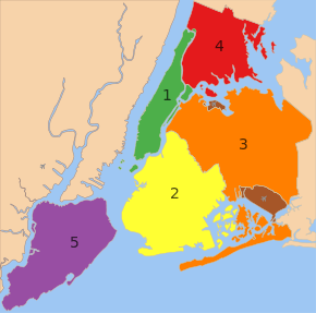
The five boroughs: 1: Manhattan, 2: Brooklyn, 3: Queens, 4: The Bronx, 5: Staten Island
The neighborhoods in New York City are located within the five boroughs of the City of New York. Their names and borders are not officially defined, and they change from time to time.[1]
Boroughs
Main article: Borough (New York City)
New York City is split up into five boroughs, which are the Bronx, Brooklyn, Manhattan, Queens, and Staten Island. Each borough has the same boundaries as a county of the state. The county governments were dissolved when the city consolidated in 1898, along with all city, town, and village governments within each county. The term borough was adopted to describe a unique form of governmental administration for each of the five fundamental constituent parts of the newly consolidated city.
Community areas
Further information: Community Boards in New York City
Riverdale, The Bronx

Prospect Heights, Brooklyn
Upper East Side, Manhattan
Flushing, Queens
St. George, Staten Island
| Community Board (CB) | Area km2 | Pop. Census 2010 | Pop./ km2 | Neighborhoods |
|---|---|---|---|---|
| Bronx CB 1 | 7.17 | 91,497 | 12,761 | Melrose, Mott Haven, Port Morris |
| Bronx CB 2 | 5.54 | 52,246 | 9,792 | Hunts Point, Longwood |
| Bronx CB 3 | 4.07 | 79,762 | 19,598 | Claremont, Concourse Village, Crotona Park, Morrisania |
| Bronx CB 4 | 5.28 | 146,441 | 27,735 | Concourse, High Bridge |
| Bronx CB 5 | 3.55 | 128,200 | 36,145 | Fordham, Morris Heights, Mount Hope, University Heights |
| Bronx CB 6 | 4.01 | 83,268 | 20,765 | Bathgate, Belmont, East Tremont, West Farms |
| Bronx CB 7 | 4.84 | 139,286 | 28,778 | Bedford Park, Norwood, University Heights |
| Bronx CB 8 | 8.83 | 101,731 | 11,521 | Fieldston, Kingsbridge, Kingsbridge Heights, Marble Hill, Riverdale, Spuyten Duyvil, Van Cortlandt Village |
| Bronx CB 9 | 12.41 | 172,298 | 13,884 | Bronx River, Bruckner, Castle Hill, Clason Point, Harding Park, Parkchester, Soundview, Unionport |
| Bronx CB 10 | 16.76 | 120,392 | 7,183 | City Island, Co-op City, Locust Point, Pelham Bay, Silver Beach, Throgs Neck, Westchester Square |
| Bronx CB 11 | 9.32 | 113,232[2] | 12,149 | Allerton, Bronxdale, Indian Village, Laconia, Morris Park, Pelham Gardens, Pelham Parkway, Van Nest[3][4] |
| Bronx CB 12 | 14.56 | 152,344 | 10,463 | Baychester, Edenwald, Eastchester, Fish Bay, Olinville, Wakefield, Williamsbridge, Woodlawn |
| Brooklyn CB 1 | 12.82 | 160,338 | 12,507 | Greenpoint, Williamsburg |
| Brooklyn CB 2 | 7.72 | 98,620 | 12,775 | Boerum Hill, Brooklyn Heights, Brooklyn Navy Yard, Clinton Hill, DUMBO, Fort Greene, Fulton Ferry, Fulton Mall, Vinegar Hill |
| Brooklyn CB 3 | 7.67 | 143,867 | 18,757 | Bedford-Stuyvesant, Ocean Hill, Stuyvesant Heights |
| Brooklyn CB 4 | 5.31 | 104,358 | 19,653 | Bushwick |
| Brooklyn CB 5 | 14.61 | 173,198 | 11,855 | City Line, Cypress Hills, East New York, Highland Park, New Lots, Starrett City |
| Brooklyn CB 6 | 9.01 | 104,054 | 11,549 | Carroll Gardens, Cobble Hill, Gowanus, Park Slope, Red Hook |
| Brooklyn CB 7 | 10.96 | 120,063 | 10,955 | Greenwood Heights, Sunset Park, Windsor Terrace |
| Brooklyn CB 8 | 4.25 | 96,076 | 22,606 | Crown Heights, Prospect Heights, Weeksville |
| Brooklyn CB 9 | 4.07 | 104,014 | 25,556 | Crown Heights, Prospect Lefferts Gardens, Wingate |
| Brooklyn CB 10 | 10.57 | 122,542 | 11,593 | Bay Ridge, Dyker Heights, Fort Hamilton |
| Brooklyn CB 11 | 10.18 | 172,129 | 16,909 | Bath Beach, Bensonhurst, Gravesend, Mapleton |
| Brooklyn CB 12 | 9.32 | 185,046 | 19,855 | Borough Park, Kensington, Midwood, Ocean Parkway |
| Brooklyn CB 13 | 8.88 | 106,120 | 11,950 | Bensonhurst, Brighton Beach, Coney Island, Gravesend, Sea Gate |
| Brooklyn CB 14 | 7.61 | 168,806 | 22,182 | Flatbush, Kensington, Midwood, Ocean Parkway |
| Brooklyn CB 15 | 12.82 | 160,319 | 12,505 | East Gravesend, Gerritsen Beach, Homecrest, Kings Bay, Kings Highway, Madison, Manhattan Beach, Plum Beach, Sheepshead Bay |
| Brooklyn CB 16 | 4.97 | 85,343 | 17,172 | Brownsville, Ocean Hill |
| Brooklyn CB 17 | 8.73 | 165,753 | 18,987 | Ditmas Village, East Flatbush, Erasmus, Farragut, Remsen Village, Rugby |
| Brooklyn CB 18 | 24.68 | 194,653 | 7,887 | Bergen Beach, Canarsie, Flatlands, Georgetown, Marine Park, Mill Basin, Mill Island |
| Manhattan CB 1 | 4.45 | 34,420 | 7,735 | Battery Park City, Financial District, TriBeCa |
| Manhattan CB 2 | 4.01 | 93,119 | 23,222 | Chinatown, Greenwich Village, Little Italy, Lower East Side, NoHo, SoHo, West Village |
| Manhattan CB 3 | 4.56 | 164,407 | 36,054 | Alphabet City, Chinatown, East Village, Lower East Side, Two Bridges |
| Manhattan CB 4 | 5.41 | 87,479 | 16,170 | Chelsea, Clinton |
| Manhattan CB 5 | 4.25 | 44,028 | 10,360 | Midtown |
| Manhattan CB 6 | 3.55 | 136,152 | 38,353 | Gramercy Park, Kips Bay, Murray Hill, Peter Cooper Village, Stuyvesant Town, Sutton Place, Tudor City, Turtle Bay, Waterside Plaza |
| Manhattan CB 7 | 5.46 | 207,699 | 38,040 | Lincoln Square, Manhattan Valley, Upper West Side |
| Manhattan CB 8 | 5.13 | 217,063 | 42,312 | Lenox Hill, Roosevelt Island, Upper East Side, Yorkville |
| Manhattan CB 9 | 3.91 | 111,724 | 28,574 | Hamilton Heights, Manhattanville, Morningside Heights |
| Manhattan CB 10 | 3.63 | 107,109 | 29,507 | Harlem, Polo Grounds |
| Manhattan CB 11 | 5.75 | 117,743 | 20,477 | East Harlem, Randall’s Island, Spanish Harlem, Wards Island |
| Manhattan CB 12 | 7.64 | 208,414 | 27,279 | Inwood, Washington Heights |
| Queens CB 1 | 14.97 | 211,220 | 14,110 | Astoria, Ditmars, Garden Bay, Long Island City, Old Astoria, Queensbridge, Ravenswood, Steinway, Woodside |
| Queens CB 2 | 13.36 | 109,920 | 8,228 | Hunters Point, Long Island City, Sunnyside, Woodside |
| Queens CB 3 | 7.33 | 169,083 | 23,067 | East Elmhurst, Jackson Heights, North Corona |
| Queens CB 4 | 6.16 | 167,005 | 27,111 | Corona, Elmhurst, Roosevelt Avenue |
| Queens CB 5 | 19.63 | 165,911 | 8,452 | Fresh Pond, Glendale, Maspeth, Middle Village, Liberty Park, Ridgewood |
| Queens CB 6 | 7.59 | 115,967 | 15,279 | Forest Hills, Rego Park |
| Queens CB 7 | 32.97 | 242,952 | 7,369 | Bay Terrace, Beechhurst, College Point, Flushing, Linden Hill, Malba, Queensboro Hill, Whitestone, Willets Point |
| Queens CB 8 | 19.17 | 146,594 | 7,647 | Briarwood, Cunningham Heights, Flushing South, Fresh Meadows, Hilltop Village, Holliswood, Jamaica Estates, Kew Gardens Hills, Pomonok Houses, Utopia |
| Queens CB 9 | 10.08 | 141,608 | 14,048 | Kew Gardens, Ozone Park, Richmond Hill, Woodhaven |
| Queens CB 10 | 16.19 | 127,274 | 7,861 | Howard Beach, Lindenwood, Richmond Hill, South Ozone Park, Tudor Village |
| Queens CB 11 | 24.99 | 116,404 | 4,658 | Auburndale, Bayside, Douglaston, East Flushing, Hollis Hills, Little Neck, Oakland Gardens |
| Queens CB 12 | 25.46 | 223,602 | 8,782 | Baisley Park, Jamaica, Hollis, Rochdale Village, St. Albans, South Jamaica, Springfield Gardens |
| Queens CB 13 | 33.31 | 196,284 | 5,893 | Bellerose, Brookville, Cambria Heights, Floral Park, Glen Oaks, Laurelton, Meadowmere, New Hyde Park, Queens Village, Rosedale |
| Queens CB 14 | 23.28 | 106,686 | 4,583 | Arverne, Bayswater, Belle Harbor, Breezy Point, Edgemere, Far Rockaway, Neponsit, Rockaway Park |
| Staten Island CB 1 | 36.62 | 162,609 | 4,440 | Arlington, Castleton Corners, Clifton, Concord, Elm Park, Fort Wadsworth, Graniteville, Grymes Hill, Livingston, Mariners Harbor, Meiers Corners, New Brighton, Port Ivory, Port Richmond, Randall Manor, Rosebank, St. George, Shore Acres, Silver Lake, Stapleton, Sunnyside, Tompkinsville, West Brighton, Westerleigh |
| Staten Island CB 2 | 54.62 | 127,071 | 2,326 | Arrochar, Bloomfield, Bulls Head, Chelsea, Dongan Hills, Egbertville, Emerson Hill, Grant City, Grasmere, Midland Beach, New Dorp, New Springville, Oakwood, Ocean Breeze, Old Town, South Beach, Todt Hill, Travis |
| Staten Island CB 3 | 58.97 | 152,908 | 2,593 | Annadale, Arden Heights, Bay Terrace, Charleston, Eltingville, Great Kills, Greenridge, Huguenot, Pleasant Plains, Prince’s Bay, Richmond Valley, Rossville, Tottenville, Woodrow |
| New York City | 831.39 | 8,008,278 | 9,632 |
See also
- List of Manhattan neighborhoods
- List of Bronx neighborhoods
- List of Brooklyn neighborhoods
- List of Queens neighborhoods
- List of Staten Island neighborhoods
- New York City ethnic enclaves
References
- ↑ MICHAEL M. GRYNBAUM (September 9, 2012). "Amateur Mapmakers Reshape Neighborhoods". New York Times.
- ↑ "Bronx Community District 11 Profile". NYC Department of City Planning. Retrieved 11 September 2015.
- ↑ "About CB11". Bronx Community Board 11. Retrieved 11 September 2015.
- ↑ Hu, Winnie. "Bronx Neighborhood Fights for Its Spot on the Map" The New York Times (April 6, 2014)
External links
- NYCwiki, devoted to New York City's neighborhoods
This article is issued from Wikipedia - version of the 5/15/2016. The text is available under the Creative Commons Attribution/Share Alike but additional terms may apply for the media files.


