National Register of Historic Places listings in West Denver
This is a list of the National Register of Historic Places listings in West Denver, Colorado.
This is intended to be a complete list of the properties and districts on the National Register of Historic Places in western Denver, Colorado, United States. West Denver is defined as being all of the city west of the Platte River. The locations of National Register properties and districts may be seen in an online map.[1]
There are 290 properties and districts listed on the National Register in Denver. West Denver includes 43 of these properties and districts, including 2 that extend into other regions; the city's remaining properties and districts are listed elsewhere. Another property was once listed but has been removed.
- This National Park Service list is complete through NPS recent listings posted December 2, 2016.[2]
| Adams - Alamosa - Arapahoe - Archuleta - Baca - Bent - Boulder - Broomfield - Chaffee - Cheyenne - Clear Creek - Conejos - Costilla - Crowley - Custer - Delta - Denver - Dolores - Douglas - Eagle - El Paso - Elbert - Fremont - Garfield - Gilpin - Grand - Gunnison - Hinsdale - Huerfano - Jackson - Jefferson - Kiowa - Kit Carson - La Plata - Lake - Larimer - Las Animas - Lincoln - Logan - Mesa - Mineral - Moffat - Montezuma - Montrose - Morgan - Otero - Ouray - Park - Phillips - Pitkin - Prowers - Pueblo - Rio Blanco - Rio Grande - Routt - Saguache - San Juan - San Miguel - Sedgwick - Summit - Teller - Washington - Weld - Yuma |
Current listings
| [3] | Name on the Register[4] | Image | Date listed[5] | Location | Neighborhood | Description |
|---|---|---|---|---|---|---|
| 1 | 19th Street Bridge | 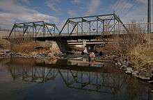 |
(#85000201) |
19th St. 39°45′36″N 105°00′12″W / 39.76°N 105.003333°W |
Highland | Extends into Union Station in Downtown Denver |
| 2 | All Saints Episcopal Church | 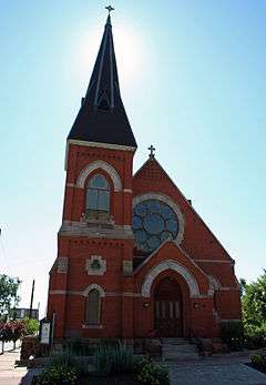 |
(#78000839) |
2222 W. 32nd Ave. 39°45′43″N 105°00′49″W / 39.761944°N 105.013611°W |
Highland | |
| 3 | Avoca Lodge | |
(#89002373) |
2690 S. Wadsworth Boulevard 39°40′05″N 105°04′50″W / 39.668056°N 105.080556°W |
Bear Valley | |
| 4 | Berkeley Lake Park | |
(#86002255) |
Roughly bounded by the northern side of Berkeley Lake, Tennyson St., W. 46th Ave., and Sheridan Boulevard 39°46′56″N 105°02′52″W / 39.782222°N 105.047778°W |
Berkeley | |
| 5 | Berkeley School | 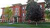 |
(#96001237) |
5025-5055 Lowell Boulevard 39°47′19″N 105°02′04″W / 39.788611°N 105.034444°W |
Regis | |
| 6 | William Norman Bowman House-Yamecila | 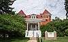 |
(#91000295) |
325 King St. 39°43′21″N 105°02′01″W / 39.7225°N 105.033611°W |
Barnum | |
| 7 | Bryant-Webster Elementary School | 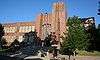 |
(#95001421) |
3635 Quivas St. 39°46′03″N 105°00′28″W / 39.7675°N 105.007778°W |
Highland | |
| 8 | Building at 1389 Stuart Street |  |
(#82002287) |
1389 Stuart St. 39°44′17″N 105°02′33″W / 39.738056°N 105.0425°W |
West Colfax | |
| 9 | Building at 1390 Stuart Street | 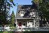 |
(#82002288) |
1390 Stuart St. 39°44′17″N 105°02′32″W / 39.738056°N 105.042222°W |
West Colfax | |
| 10 | Building at 1435 Stuart Street |  |
(#82002289) |
1435 Stuart St. 39°44′22″N 105°02′33″W / 39.739444°N 105.0425°W |
West Colfax | |
| 11 | Building at 1444 Stuart Street | 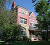 |
(#82002290) |
1444 Stuart St. 39°44′23″N 105°02′32″W / 39.739722°N 105.042222°W |
West Colfax | |
| 12 | Building at 1471 Stuart Street | 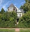 |
(#82002291) |
1471 Stuart St. 39°44′23″N 105°02′33″W / 39.739722°N 105.0425°W |
West Colfax | |
| 13 | Denver Tramway Powerhouse | 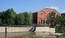 |
(#01000940) |
1416 Platte St. 39°45′18″N 105°00′32″W / 39.755°N 105.008889°W |
Highland | |
| 14 | Dickinson Branch Library | 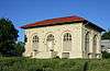 |
(#02000262) |
1545 Hooker St. 39°44′29″N 105°01′41″W / 39.741389°N 105.028056°W |
West Colfax | |
| 15 | William J. Dunwoody House | 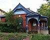 |
(#79000582) |
2637 W. 26th Ave. 39°45′18″N 105°01′11″W / 39.755°N 105.019722°W |
Jefferson Park | |
| 16 | Elitch Theatre | 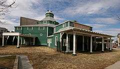 |
(#78000844) |
W. 38th Ave. and Tennyson St. 39°46′06″N 105°02′46″W / 39.768333°N 105.046111°W |
West Highland | |
| 17 | Fourth Church of Christ, Scientist | 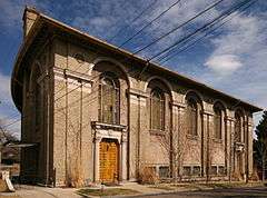 |
(#04000336) |
3101 W. 31st Ave. 39°45′40″N 105°01′37″W / 39.761111°N 105.026944°W |
West Highland | |
| 18 | Hanigan-Canino Terrace | |
(#87001289) |
1421-1435 W. 35th Ave. 39°45′57″N 105°00′12″W / 39.765833°N 105.003333°W |
Highland | |
| 19 | Highland Park | 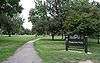 |
(#86002248) |
Roughly bounded by Highland Park Pl., Federal Boulevard, and Fairview Pl. 39°45′47″N 105°01′34″W / 39.763056°N 105.026111°W |
West Highland | |
| 20 | Highland Park Historic District | 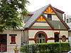 |
(#85000082) |
Bounded by Zuni St., Dunkeld Pl., Clay St., and 32nd Ave. 39°45′39″N 105°01′02″W / 39.760833°N 105.017222°W |
Highland | |
| 21 | Highlands Masonic Lodge | 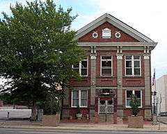 |
(#95001337) |
3220 Federal Boulevard 39°45′45″N 105°01′27″W / 39.7625°N 105.024167°W |
Highland | |
| 22 | Inspiration Point | |
(#86002259) |
Roughly bounded by W. 50th Ave., Sheridan Boulevard, W. 49th Ave., and Fenton St. 39°47′11″N 105°03′22″W / 39.786389°N 105.056111°W |
Regis | |
| 23 | Loretto Heights Academy | 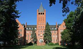 |
(#75000510) |
3001 S. Federal Boulevard 39°39′42″N 105°01′38″W / 39.661667°N 105.027222°W |
Harvey Park South | |
| 24 | Frederick W. Neef House | 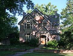 |
(#79000588) |
2143 Grove St. 39°44′59″N 105°01′35″W / 39.749722°N 105.026389°W |
Sloan Lake | |
| 25 | Niblock-Yacovetta Terrace | 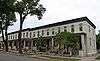 |
(#86001450) |
1301-1319 W. 35th Ave. 39°45′57″N 105°00′12″W / 39.765833°N 105.003333°W |
Highland | |
| 26 | Old Highland Business District | |
(#79000589) |
15th and Boulder Sts. 39°45′29″N 105°00′38″W / 39.758056°N 105.010556°W |
Highland | |
| 27 | Oriental Theater | 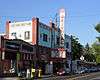 |
(#97001167) |
4329-39 W. 44th Ave. 39°46′37″N 105°02′35″W / 39.776944°N 105.043056°W |
Berkeley | |
| 28 | Overland Cotton Mill | 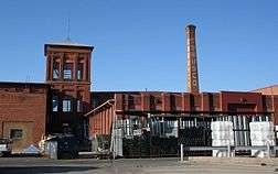 |
(#01000288) |
1314 W. Evans Ave. 39°40′36″N 105°00′13″W / 39.676667°N 105.003611°W |
College View and South Platte | |
| 29 | Potter Highlands Historic District | 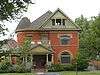 |
(#86000097) |
Roughly bounded by W. 38th Ave., Zuni St., W. 32nd Ave., and Federal Boulevard 39°45′53″N 105°01′09″W / 39.764722°N 105.019167°W |
Highland | |
| 30 | Rocky Mountain Hotel | 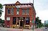 |
(#83001314) |
2301 7th St. 39°45′08″N 105°00′51″W / 39.752222°N 105.014167°W |
Jefferson Park | |
| 31 | Rocky Mountain Lake Park | |
(#86002250) |
Roughly bounded by Interstate 70, Federal Boulevard, W. 46th Ave., and Lowell Boulevard 39°46′55″N 105°01′47″W / 39.781944°N 105.029722°W |
Berkeley | |
| 32 | Romeo Block | 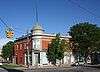 |
(#95001485) |
2944 Zuni St. 39°45′33″N 105°00′54″W / 39.759167°N 105.015°W |
Highland | |
| 33 | Amos H. Root Building | 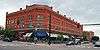 |
(#80000894) |
1501-1529 Platte St. 39°45′24″N 105°00′32″W / 39.756667°N 105.008889°W |
Highland | |
| 34 | St. Dominic's Church | 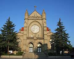 |
(#96001236) |
3005 W. 29th Ave. 39°45′32″N 105°01′31″W / 39.758889°N 105.025278°W |
West Highland | |
| 35 | St. Elizabeth's Retreat Chapel | 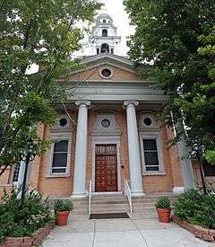 |
(#76000556) |
2825 W. 32nd Ave. 39°45′46″N 105°01′19″W / 39.762778°N 105.021944°W |
Highland | |
| 36 | St. Joseph's Polish Roman Catholic Church | 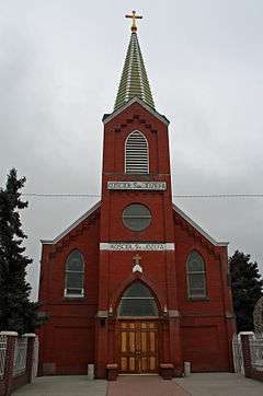 |
(#83001315) |
517 E. 46th Ave. 39°46′49″N 104°58′54″W / 39.780278°N 104.981667°W |
Globeville | |
| 37 | St. Patrick Mission Church | 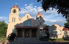 |
(#79000593) |
3325 Pecos St. 39°45′49″N 105°00′23″W / 39.763611°N 105.006389°W |
Highland | |
| 38 | George Schmidt House | 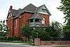 |
(#76000554) |
2345 7th St. 39°45′10″N 105°00′52″W / 39.752778°N 105.014444°W |
Jefferson Park | |
| 39 | South Platte River Bridges | |
(#02001128) |
Interstate 25 at milepost 210.53 39°44′36″N 105°00′56″W / 39.743333°N 105.015556°W |
Jefferson Park and Sun Valley | Extends into Auraria in Northeast Denver |
| 40 | Stonemen's Row Historic District | 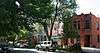 |
(#84000824) |
Southern side of 28th Ave. between Umatilla and Vallejo Sts. 39°45′26″N 105°00′43″W / 39.757222°N 105.011944°W |
Highland | |
| 41 | Tallmadge and Boyer Block | |
(#82001013) |
2926-2942 Zuni St. 39°45′32″N 105°00′54″W / 39.758889°N 105.015°W |
Highland | |
| 42 | Tilden School for Teaching Health | 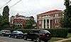 |
(#95001068) |
Junction of W. Fairview Pl. and Grove St. 39°45′51″N 105°01′41″W / 39.764167°N 105.028056°W |
West Highland | |
| 43 | West Forty-sixth Avenue Parkway | 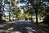 |
(#86002249) |
W. 46th Ave. Parkway from Stuart St. to Grove St. 39°46′49″N 105°01′33″W / 39.780278°N 105.025833°W |
Berkeley |
Former listing
| [3] | Name on the Register | Image | Date listed | Date removed | Location | Summary |
|---|---|---|---|---|---|---|
| 1 | Wheeler House | 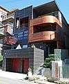 |
(#00000105) | 1917 W. 32nd Ave. 39°45′44″N 105°00′34″W / 39.7622°N 105.0094°W |
Demolished in 2005[6] |
See also
| Wikimedia Commons has media related to National Register of Historic Places in Denver, Colorado. |
- List of National Historic Landmarks in Colorado
- National Register of Historic Places listings in Denver, Colorado
References
- ↑ The latitude and longitude information provided in this table was derived originally from the National Register Information System, which has been found to be fairly accurate for about 99% of listings. For about 1% of NRIS original coordinates, experience has shown that one or both coordinates are typos or otherwise extremely far off; some corrections may have been made. A more subtle problem causes many locations to be off by up to 150 yards, depending on location in the country: most NRIS coordinates were derived from tracing out latitude and longitudes off of USGS topographical quadrant maps created under the North American Datum of 1927, which differs from the current, highly accurate WGS84 GPS system used by most on-line maps. Chicago is about right, but NRIS longitudes in Washington are higher by about 4.5 seconds, and are lower by about 2.0 seconds in Maine. Latitudes differ by about 1.0 second in Florida. Some locations in this table may have been corrected to current GPS standards.
- ↑ "National Register of Historic Places: Weekly List Actions". National Park Service, United States Department of the Interior. Retrieved on December 2, 2016.
- 1 2 Numbers represent an ordering by significant words. Various colorings, defined here, differentiate National Historic Landmarks and historic districts from other NRHP buildings, structures, sites or objects.
- ↑ National Park Service (2010-07-09). "National Register Information System". National Register of Historic Places. National Park Service.
- ↑ The eight-digit number below each date is the number assigned to each location in the National Register Information System database, which can be viewed by clicking the number.
- ↑
This article is issued from Wikipedia - version of the 11/30/2016. The text is available under the Creative Commons Attribution/Share Alike but additional terms may apply for the media files.