National Register of Historic Places listings in Marinette County, Wisconsin

Location of Marinette County in Wisconsin
This is a list of the National Register of Historic Places listings in Marinette County, Wisconsin. It is intended to provide a comprehensive listing of entries in the National Register of Historic Places that are located in Marinette County, Wisconsin. The locations of National Register properties for which the latitude and longitude coordinates are included below may be seen in a map.[1]
There are 12 properties and districts listed on the National Register in the county.
- This National Park Service list is complete through NPS recent listings posted December 2, 2016.[2]
Current listings
| [3] | Name on the Register[4] | Image | Date listed[5] | Location | City or town | Description |
|---|---|---|---|---|---|---|
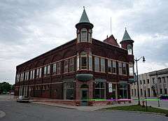
| 1 | Amberg Town Hall |  |
(#81000048) |
One third mile off U.S. 141 on County V. 45°30′09″N 87°59′40″W / 45.5025°N 87.994444°W |
Amberg | Designed by Charles Maass of Marinette in Queen Anne style and built in 1894, the hall housed a jail, a clerk's office and a community hall used for live entertainers, Christmas plays, meetings, dances and basketball games.[6] |
| 2 | Bijou Theatre Building | Upload image | (#93000159) |
1722-1726 Main St. 45°05′58″N 87°37′47″W / 45.099444°N 87.629722°W |
Marinette | Classical Revival building built in 1905 as a department store and vaudeville theater for Frank Lauerman. As vaudeville succumbed to motion pictures, it was converted to a movie theater.[7] |
| 3 | Mary and Harry Brown House |  |
(#15000713) |
1931 Riverside Ave. 45°06′08″N 87°37′57″W / 45.1023°N 87.6325°W |
Marinette | Lumber baron and Senator Isaac Stephenson had this house along the Menominee River built in 1885 in Queen Anne style for his daughter Mary. In the 1920s it was remodelled to the then-more-fashionable Tudor Revival style.[8] |
| 4 | Chautauqua Grounds Site | |
(#97000367) |
Address Restricted |
Marinette | An archaeological site of the Old Copper Culture.[9] |
| 5 | Dunlap Square Building |  |
(#92000026) |
1821 Hall St. 45°05′58″N 87°37′55″W / 45.099444°N 87.631944°W |
Marinette | This Queen Anne styled business block built from 1890 to 1902 has housed a drug store, a saloon, a telephone exchange, restaurants, shops, and various offices.[10] |
| 6 | Independent Order of Odd Fellows-Lodge No. 189 Building | Upload image | (#98001597) |
1335 Main St. 45°05′42″N 87°37′18″W / 45.095°N 87.621667°W |
Marinette | Two-story brick Odd Fellows lodge built in 1889.[11] |
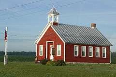
| 7 | Lena Road School |  |
(#02000415) |
N2155 US 141 45°02′19″N 88°02′42″W / 45.038611°N 88.045°W |
Pound | Simple, classic one-room school built by local farmers in 1911 and used as a school until 1959.[12][13] Listed on NRHP as the Kena Road School. |
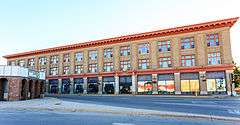
| 8 | Lauerman Brothers Department Store |  |
(#92000027) |
1701-1721 Dunlap Sq. 45°05′58″N 87°37′51″W / 45.099444°N 87.630833°W |
Marinette | The flagship of a multi-state chain of department stores based in Marinette. Complex includes the early Italianate-styled business block, the department store built from 1904 to 1924 designed in Chicago Commercial style, and the warehouse built in 1920.[14][15] |
| 9 | F.J. Lauerman House | Upload image | (#79000094) |
383 State St. 45°06′00″N 87°38′21″W / 45.1°N 87.639167°W |
Marinette | Spanish Colonial Revival-styled home built in 1901 for Frank Lauerman of the department store, and called Casa del Flores.[16] |
| 10 | Milwaukee Road Depot | _September_2013_02.jpg) |
(#04001485) |
650 Hattie St. 45°05′55″N 87°38′17″W / 45.098611°N 87.638056°W |
Marinette | Stick style depot built in 1903 by the Milwaukee Road,[17] originally with a women's waiting room on one end and men's on the other. |
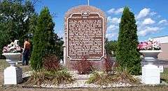
| 11 | Peshtigo Fire Cemetery |  |
(#70000037) |
Oconto Ave. between Peck and Ellis Aves. 45°03′23″N 87°45′15″W / 45.056389°N 87.754167°W |
Peshtigo | Graves of victims of the fire of 1871, including a mass grave of 300 men, women and children who could not be identified.[18] |
| 12 | Peshtigo Reef Light | Upload image | (#07000404) |
Offshore in lower Green Bay, approx. 3.3 mi (5.3 km). SE of Peshtigo Point 44°57′31″N 87°34′48″W / 44.958611°N 87.58°W |
Peshtigo Township | Lighthouse built in 1936 to warn ships of the shoal which runs out three miles from the mouth of the Peshtigo River. A daymark marked the shoal from 1869 to 1906 and a lightship from then to 1936.[19] (ARLHS USA 951) |
See also
- List of National Historic Landmarks in Wisconsin
- National Register of Historic Places listings in Wisconsin
References
- ↑ The latitude and longitude information provided is primarily from the National Register Information System, and has been found to be fairly accurate for about 99% of listings. For 1%, the location info may be way off. We seek to correct the coordinate information wherever it is found to be erroneous. Please leave a note in the Discussion page for this article if you believe any specific location is incorrect.
- ↑ "National Register of Historic Places: Weekly List Actions". National Park Service, United States Department of the Interior. Retrieved on December 2, 2016.
- ↑ Numbers represent an ordering by significant words. Various colorings, defined here, differentiate National Historic Landmarks and historic districts from other NRHP buildings, structures, sites or objects.
- ↑ National Park Service (2008-04-24). "National Register Information System". National Register of Historic Places. National Park Service.
- ↑ The eight-digit number below each date is the number assigned to each location in the National Register Information System database, which can be viewed by clicking the number.
- ↑ "Amberg Town Hall". National Register or State Register. Wisconsin Historical Society. Retrieved 2013-10-09.
- ↑ "Bijou Theater Building". National Register or State Register. Wisconsin Historical Society. Retrieved 2013-10-13.
- ↑ "Brown, Mary and Harry, House". National Register or State Register. Wisconsin Historical Society. Retrieved 2015-10-17.
- ↑ "The Old Copper Complex". Retrieved 2013-10-13.
- ↑ "Dunlap Square Building". Architecture and History Inventory. Wisconsin Historical Society. Retrieved 2013-10-16.
- ↑ "Independent Order of Odd Fellows-Lodge #189". Architecture and History Inventory. Wisconsin Historical Society. Retrieved 2013-10-16.
- ↑ "Lena Road School". National Register or State Register. Wisconsin Historical Society. Retrieved 2013-10-16.
- ↑ "Lena Road School". Architecture and History Inventory. Wisconsin Historical Society. Retrieved 2013-10-16.
- ↑ "Lauerman Brothers Department Store". Architecture and History Inventory. Wisconsin Historical Society. Retrieved 2013-10-21.
- ↑ "Lauerman's Department Store". Architecture and History Inventory. Wisconsin Historical Society. Retrieved 2013-10-21.
- ↑ "F. J. Lauerman House". Architecture and History Inventory. Wisconsin Historical Society. Retrieved 2013-10-21.
- ↑ "Milwaukee Road Depot". Architecture and History Inventory. Wisconsin Historical Society. Retrieved 2013-10-24.
- ↑ "Peshtigo Fire Cemetery Marker". Photograph. Wisconsin Historical Society. Retrieved 2013-10-24.
- ↑ Pepper, Terry. "Peshtigo Reef Light". Seeing the Light. Terry Pepper. Retrieved 2013-10-24.
| Wikimedia Commons has media related to National Register of Historic Places in Marinette County, Wisconsin. |
This article is issued from Wikipedia - version of the 5/15/2016. The text is available under the Creative Commons Attribution/Share Alike but additional terms may apply for the media files.