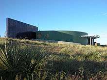
National Historic Trails Interpretive Center
 | |
| Established | 2002 |
|---|---|
| Location |
1501 North Poplar Street Casper, Wyoming, United States |
| Type | Interpretive Center |
| Website | Official website |
The National Historic Trails Interpretive Center (NHTIC) is a 11,000-square-foot (1,000 m2) interpretive center [1] about several of the National Historic Trails, and is located northwest of Casper, Wyoming on Interstate 25. It is operated through a partnership between the Bureau of Land Management, the City of Casper, and the National Historic Trails Center Foundation. The center offers interpretive programs, exhibits, multi-media presentations, and special events.[2]
History
The idea for an interpretive center in Casper began with the creation of a small trails committee; eventually this committee became the non-profit, National Historic Trails Center Foundation (NHTCF). In 1992 the Bureau of Land Management (BLM) joined with the NHTCF to work on the project, committing to pay half of the $10 million estimated cost. The City of Casper donated 10 acres of land for the center's site.[3]
In 1994, voters in Casper passed the Optional One Cent Tax, which helped to fund construction of the center's exhibits. The Wyoming State Legislature also passed a bill to help fund the center that same year. By 1997 plans for the center were complete, and a bill, to support construction and operating costs, passed both houses of congress and was signed into law by President Bill Clinton.[3]
The groundbreaking for construction took place on June 21, 1999 and the center officially opened August 9, 2002.[3]

Exhibits
The center contains several permanent exhibits, and hosts temporary, traveling, exhibits as well.[4]
Permanent Exhibits include:
An entrance fee is required for admission into the center.[2]
See also
- National Historic Trail
- National Historic Oregon Trail Interpretive Center
- Oregon-California Trails Association
- Martin's Cove
- Mormon pioneers
- List of Registered Historic Places in Wyoming
References
- ↑ "National Historic Trails Interpretive Center". Hands on the Land Network. 2010. Retrieved 2010-09-29.
- 1 2 "Trails Center". Bureau of Land Management. 2010. Retrieved 2010-09-29.
- 1 2 3 "History of the Center & Partnerships". Bureau of Land Management. 2010. Retrieved 2010-09-29.
- ↑ "Temporary Exhibits". Bureau of Land Management. 2010. Retrieved 2010-09-29.
External links
- National Historic Trails Interpretive Center - official site
Coordinates: 42°51′59″N 106°20′15″W / 42.866457°N 106.337413°W