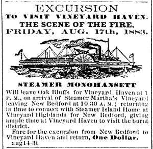
Monohansett (steamboat)


Monohansett was a sidewheel steamer operating as a ferry serving the island of Martha's Vineyard during the late nineteenth century. She was named after Monohansett Island, a tiny 12-acre (4.9-hectare) island off Naushon Island.[1]
Construction
Monohansett was built in 1862 by the New Bedford, Martha's Vineyard, & Nantucket Steamboat Company as a replacement for the steamer Eagle′s Wing, which had caught fire during a race on the Providence River off Pawtuxet in 1861 and was completely destroyed. The engine from Eagle′s Wing was fitted into the new vessel.[2] Monohansett was built in five months in the shipyard of Thomas Collier of New York under the supervision of Monohansett′s designer Captain Benjamin C. Cromwell of Vineyard Haven, Massachusetts. She was 182 feet (55 m) long, with a beam of 28 feet (8.5 m), 9 feet 6 inches (2.90 m) depth, and had a gross register tonage of 489.[1] Her keel was made of white oak, her deck timbers were of oak and white chestnut, and her tops of hackmatack and white chestnut.[3] Monohansett made her first trip to Martha's Vineyard, to the Edgartown wharf, on June 1, 1862.[1]
Civil War service
Barely two months later, on August 13, 1862, the United States Government chartered Monohansett.[1] During the American Civil War, Monohansett carried dispatches to United States Navy ships operating in the Atlantic Ocean off Cape Hatteras and Wilmington, North Carolina, as well as in the Chesapeake Bay and the Potomac River. The small screw steamer Helen Augusta operated as the substitute ferry to Martha's Vineyard during the war.[2] By the end of the war in April 1865, Monohansett was the headquarters boat at City Point, Virginia, and was used by General Ulysses S. Grant as a dispatch boat.[1] General Grant reportedly was very fond of Monohansett, and President Abraham Lincoln and his wife also spent time aboard her.[3]
Vineyard ferry service
Monohansett returned to service as a Martha's Vineyard ferry in June 1865.[4] In the summer of 1874, now-President Grant used the Monohansett to visit Martha's Vineyard, arriving in Cottage City (now Oak Bluffs).[1]
Monohansett was first commanded by Captain Benjamin C. Cromwell, her designer, and during the American Civil War by Hiram Crowell.[3] Captain Charles C. Smith (b. 1826), who served as first mate under Captain Crowell during war duty, became captain of Monohansett in 1867, and was still master in 1885.[4] At some point a Captain Marshall, evidently Francis J. Marshall (1857-1933) of Edgartown, Massachusetts, is said to have been her captain;[5] Marshall also commanded the steamboat Martha's Vineyard, and would later command the steamboat Uncatena.[2]
Although Monohansett was primarily a Vineyard boat, she occasionally would make trips to Nantucket, especially during wintertime "freeze-ups," when Monohansett would force her way through ice to relieve the isolated Nantucket residents.[2]
Final years
Monohansett was sold in 1901[1] or 1903[3] (sources vary), and was used around Bostion, Massachusetts, and the Massachusetts North Shore. On 28 June 1904, she was wrecked in a dense fog on Little Misery Island in the Misery Islands in Salem Harbor, Massachusetts, while headed to Boston from Gloucester, Massachusetts.[2]
Notes
- 1 2 3 4 5 6 7 Banks, Charles E., The History of Martha's Vineyard, Mass., Volume I. (Dukes County Historical Society, 1911)
- 1 2 3 4 5 Turner, Harry B. The Story of the Island Steamers (The Inquirer and Mirror Press, 1910) Books.google.com
- 1 2 3 4 Vineyard Gazette Online
- 1 2 The Dukes County Intelligencer, Vol. 8, No. 4, May 1967.
- ↑ Notes on the Marshall Families of Martha's Vineyard, Mass
References
- Banks, Charles E., The History of Martha's Vineyard, Mass., Volume I. (Dukes County Historical Society, 1911)
- Turner, Harry B. The Story of the Island Steamers (The Inquirer and Mirror Press, 1910)
- - reprint of a 1927 article in the Vineyard Gazette
- The Dukes County Intelligencer, Vol. 8, No. 4, May 1967.
Coordinates: 42°32′45.65″N 70°47′48.12″W / 42.5460139°N 70.7967000°W