Medora Covered Bridge
|
Medora Covered Bridge | |
 | |
  | |
| Location | Medora, Indiana |
|---|---|
| Coordinates | 38°49′06″N 86°08′49″W / 38.81833°N 86.14694°WCoordinates: 38°49′06″N 86°08′49″W / 38.81833°N 86.14694°W |
| Architect | Joseph J. Daniels |
| Architectural style | Burr Arch Truss |
| NRHP Reference # | 07000977 |
| Added to NRHP | September 19, 2007 |
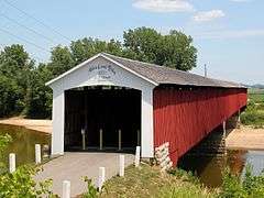
The Medora Covered Bridge is the longest-spanning (a part of a bridge between the uprights supporting it[1]) historic covered bridge in the United States.[2][3] If you consider anything beyond the face of the abutments as part of the span, the Medora Bridge siding is the longest at the floor. The roof length is also longer than any other historic covered bridge in the United States, depending on whose measurements you accept.
In the discussion of the longest historic covered bridge, the Medora Bridge has been ignored for various reasons, including the fact that it is no longer active. The fact that it is closed to vehicle traffic, however, makes it ideal for exploring the many facets that make up a covered bridge. One can mentally hop up on a buggy or horseless carriage and take a nostalgic trip back in time in a covered bridge whose structure is like it was in 1875 because it did not have to be upgraded to meet modern vehicle traffic standards.
There is ample parking at both ends. The west end has a DNR boat ramp with a parking area large enough for RV's to turn around. There is also a nice grassy area with picnic tables.
Location
The Medora Covered Bridge is located in Carr Township in Jackson County, Indiana and crosses the East Fork of the White River running parallel to State Road 235. It is approximately one mile east of Medora and nine miles southwest of Brownstown.
Construction
In the Burr Truss design of the bridge it was not necessary to extend the truss beyond the faces of the abutments. Extending the truss does not extend the clear span that is being crossed which is determined by where the faces of the abutments are placed.
The Medora Covered Bridge has two piers between the abutments. (The piers and abutments are Oolitic Limestone from the nearby Dixon Quarry.) This configuration creates three spans which means considerably less stress than two spans covering a similar distance. Each span has four arches which are seated on the skewback stones of the abutments and piers separated by a steel shoe to help prevent rotting. Each arch has six sections and each section is a single tree. The middle four sections are 20' long and the end sections are 31' long. The builders could saw the slab but not the curve. They would mark the curve top and bottom on the slab, saw close to the mark, knock out the block then finish with a shaping tool called a foot adz. The arches are designed to bear the weight of the bridge and are complimented by king posts and lateral braces which provide stability when properly coordinated. Detailed information is on the website: http://www.medoracoveredbridge.com/
History
The Medora Covered Bridge was built in 1875 by J.J. Daniels at a cost of $18,142.00 and took nine months to build. The bridge was covered to protect the truss from the elements. Before the bridge was built people crossed the river by ferry.[4]
It has been reported but not verified that at one time there was wooden railing down the middle of the bridge separating the two way traffic. As the vehicles became wider, the railing was removed and it was then one way.
Until 1935 the bridge carried U.S. Route 50 when it (U.S. 50) was moved four miles to the north.[5]
In 1968 the bridge was scheduled for demolition when the new modern parallel bridge was to be opened but was saved by an order from then Governor Whitcomb in 1971.[6]
A modern parallel bridge was opened in 1973. The covered bridge was closed to vehicular traffic at that time.[7]
In 2007, the bridge was added to the National Register of Historic Places
In June 2011 a rehab of the bridge was completed. The original truss remained in place with a few repairs. The cedar shake shingles, siding (Seven of the original boards, identified by square nail holes, were placed on the north side of the far west end.), sheeting (or sheathing) and some of the rafters were replaced. Except for the shingles, most of these items were original but badly deteriorated. Much of the flooring was replaced but was not original.
The skin took a beating, especially on the south side which was more exposed to the sun, but it did its job by protecting the bones. Without the skin, the bones would have rotted.
See also
-
 Bridges portal
 -
 Indiana portal
References
- ↑ Oxford Dictionary of Current English, Fourth Edition, Page 873
- ↑ Tippin, Morris; Barker, P.E., James (Summer 2014). Indiana Crossings, "Which Bridge Is the Longest Historic Covered Bridge?". Indiana Covered Bridge Society. p. 3.
- ↑ Miller, Terry E. (Winter 2015). "Is There a "Longest Historical Covered Bridge" in the United States?". Covered Bridge Topics.
- ↑ "Indiana State Historic Architectural and Archaeological Research Database (SHAARD)" (Searchable database). Department of Natural Resources, Division of Historic Preservation and Archaeology. Retrieved 2016-04-01. Note: This includes J.A. Barker Engineering and Fleeta Arthur (May 2006). "National Register of Historic Places Inventory Nomination Form: Medora Covered Bridge" (PDF). Retrieved 2016-04-01. and Accompanying photographs.
- ↑ First Documented History of Jackson County, Indiana. 1816-1976, Volume 2 by Edwin J. Boley, Page 337
- ↑ Outdoor Indiana Magazine; Herbert R. Hill, Editor; Sept 1971; p.23.
- ↑ Seymour Daily Tribune ; Sat, Oct. 13, 1973; Col 4-8; p. 1.
External links
![]() Media related to Medora Covered Bridge at Wikimedia Commons
Media related to Medora Covered Bridge at Wikimedia Commons

