Martinair Flight 138
| Accident summary | |
|---|---|
| Date | 4 December 1974 |
| Summary | Controlled flight into terrain |
| Site | Maskeliya, Sri Lanka |
| Passengers | 182 |
| Crew | 9 |
| Fatalities | 191 (all) |
| Survivors | 0 |
| Aircraft type | McDonnell Douglas DC-8-55CF[1] |
| Operator | Martinair on behalf of Garuda Indonesia |
| Registration | PH-MBH |
| Flight origin | Juanda International Airport, Surabaya, Indonesia |
| Stopover | Bandaranaike International Airport, Colombo, Sri Lanka |
| Destination | Jeddah International Airport, Jeddah, Saudi Arabia |
Martinair Flight 138 was a chartered flight from Surabaya, Indonesia to Colombo, Sri Lanka. The aircraft was operated on behalf of Garuda Indonesia. On 4 December 1974, the aircraft, a McDonnell Douglas DC-8-55CF,[1] crashed into a mountain shortly before landing, killing all 191 people aboard – 182 Indonesian hajj pilgrims bound for Mecca, and 9 crew members.[2]
The flight is said to have departed Surabaya, Indonesia at approximately 12.03 UTC heading to Jeddah planning a stop at Bandaranayake airport, Colombo, Sri Lanka. At around 16.30 UTC Colombo control cleared the flight. At 16.38 UTC another air traffic controller is said to have intervened and cleared the flight down to 5000 feet and reported clearing to 8000 feet. Colombo approach then cleared the flight down to 2000 feet at 16.44 and told the flight to expect a runway 04 approach. The crew aboard the flight were then asked to report when the airfield was in sight. The crew then continued their descent until the aircraft crashed into Saptha Kanya Mountain at an altitude of approximately 4,355 feet and at around 40 nm east of Colombo. All 191 passengers and crew were killed. The crash remains the worst in Sri Lankan aviation history and the third-deadliest involving a DC-8, after Arrow Air Flight 1285 and Nigeria Airways Flight 2120.[3] At the time, it was the second-deadliest aviation accident, after the loss of Turkish Airlines Flight 981 which occurred earlier that same year.
Information
The aircraft was a McDonnell Douglas DC-8 which carried the registration PH-MBH built in 1966. It was fitted with Pratt and Whitney engines which were modified by KLM. The aircraft was owned by the Dutch company Martinair.[3]
The crew of Flight 138 was Captain Hendrik Lamme, First Officer Robert Blomsma, Flight Engineer Johannes Wijnands, Purser Ingrid van der Vliet and Flight Attendants Henrietta Borghols, Abdul Hamid Usman, Lilik Herawati, Titia van Dijkum, and Hendrika van Hamburg.
Location
The aircraft crashed on the fifth mountain of a range of hills known as "Saptha Kanya" at Therberton estate, Maskeliya, Sri Lanka. It crashed at around 40 nautical miles from Colombo International Airport, Katunayake.[3]

Cause
Investigators listed the cause of the accident to be a "collision with rising terrain as the crew descended the aircraft below safe altitude owing to incorrect identification of their position vis-a-vis the airport. The investigation is of the opinion that this was the result of dependence on Doppler and Weather Radar Systems on board PH-MBH which left room for misinterpretation."[3]
Events leading to the accident
The aircraft took off from Surabaya International airport Indonesia at approximately 1200 hours on 4 December 1974 to proceed to Jeddah, Saudi-Arabia with a programmed stop at Katunayake International Airport, near Colombo. The aircraft contacted Katunayaka approach control at around 1616 hours indicating that they were 130 miles away and so approach reported the weather conditions and requested the aircraft to change over to Colombo area control for a descent clearance. The aircraft then descended from 35,000 feet and was handed back over to approach control. Approach control then cleared the aircraft down to 2,000 feet and the flight crew was required to report back if they sighted the airfield or if their position was overhead the 'Katunayake Non-Directional Beacon'. This message was acknowledged by the crew but there was no further communication with the aircraft. Eyewitnesses stated that the plane was flying at a level below normal and there was no evidence of a fire on board and all the engines sounded normal with no malfunctions evident. The sound of the aircraft exploding on impact was heard clearly by residents close to the site of the crash. Later it was discovered that the aircraft had crashed into the fifth mountain.[3]
Repeated attempts to make contact with the aircraft from approach control met with no success and in consultation with Colombo area control the distress phase was initiated. Search and rescue operations began subsequently. The country of registry of the aircraft (The Netherlands) and the country of manufacture (USA) were informed. Indonesia was also informed of the accident as many of the passengers were nationals of that country.[3]
Memorial
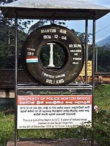
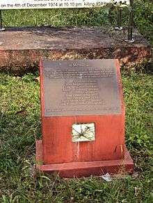
A small memorial has been built in the town of Norton Bridge, which is several miles from the crash site. In addition, a tire which was recovered from the crash site has been put on display to the public. The tire, even though displayed in public, remains property of the Norton Bridge Police. Sri Lankan artist Anton Jones sang about the incident in his song "DC8." A second memorial, placed by family members from Asia and Europe, has been put on the slopes below the place of accident. Approximately 30 years after the accident, Martinair added a plaquette with only the eight names of the crew. On the Lelystad Airfield a memorial has been placed as well. The reason for this location is unknown.


See also
References
External links
- "Report on the accident to Martinair DC-8 PH-MBH on 4th December 1974 at Theberton Estate, Maskeliya, Sri Lanka." - Posted on the website of the Aviation Safety Network (ASN)
- "Report on the Accident to Martinair DC 8 PH-MBH on 4th December 1974 at Theberton Estate, Maskeliya, Sri Lanka." Sri Lanka Ministry of Transport Department of Civil Aviation (Archive) - Posted on the website of the Civil Aviation Authority of Sri Lanka
- timelines.com Martinair Holland Flight 138 Hits Mountain Descending Into Rising Terrain
Coordinates: 6°53′32″N 80°29′26″E / 6.89222°N 80.49056°E