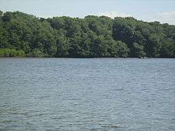
Manchón-Guamuchal
| Manchón-Guamuchal Nature Reserve | |
| Area de protección especial Manchón-Guamuchal | |
| IV | |
 Manchón Guamuchal | |
| Country | Guatemala |
|---|---|
| Region | San Marcos, Retalhuleu |
| Landmark | Litoral |
| Coordinates | GT 14°28′47″N 92°7′23″W / 14.47972°N 92.12306°WCoordinates: GT 14°28′47″N 92°7′23″W / 14.47972°N 92.12306°W |
| Area | 135 km2 (52 sq mi) |
| Biome | Littoral/intertidal zone Mangrove forests |
| Plant | mangrove forest |
| Visitation | allowed |
| Designated | 25 April 1995 |
Manchón Guamuchal is a litoral wetland zone situated along the Pacific coast of Guatemala. It is one of the last remaining mangrove forest area on the pacific coast of Guatemala and an important stop for migratory birds. It was declared a Ramsar site in 1995. [1]
References
This article is issued from Wikipedia - version of the 6/17/2014. The text is available under the Creative Commons Attribution/Share Alike but additional terms may apply for the media files.