Locust Fork of the Black Warrior River
| Locust Fork of the Black Warrior River | |
|---|---|
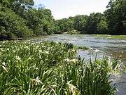
 The sandstone shelf riverscour has rare plant species | |
 | |
| Physical characteristics | |
| Length | 158-mile-long (254 km) |
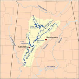
The Locust Fork in Alabama, USA, is one of three major tributaries of the Black Warrior River, stretching over Blount, Etowah, and Marshall counties. The 158-mile-long (254 km)[1] river features several stretches of whitewater, and is popular with canoers and kayakers. In the late 1980s, the Birmingham Water Works proposed damming the river as a source of drinking water. The plan was controversial, and has been suspended.
Gallery
|
References
- ↑ "The National Map". U.S. Geological Survey. Retrieved Feb 25, 2011.
External links
- Friends of the Locust Fork River website
Coordinates: 33°57′4.42″N 86°23′37.15″W / 33.9512278°N 86.3936528°W
This article is issued from Wikipedia - version of the 9/10/2016. The text is available under the Creative Commons Attribution/Share Alike but additional terms may apply for the media files.
