Locorotondo
| Locorotondo | ||
|---|---|---|
| Comune | ||
| Comune di Locorotondo | ||
|
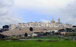
View from the Itria Valley | ||
| ||
 Locorotondo Location of Locorotondo in Italy | ||
| Coordinates: 40°45′N 17°19′E / 40.750°N 17.317°ECoordinates: 40°45′N 17°19′E / 40.750°N 17.317°E | ||
| Country | Italy | |
| Region |
| |
| Province / Metropolitan city | Bari (BA) | |
| Government | ||
| • Mayor | Tommaso Scatigna | |
| Area | ||
| • Total | 47 km2 (18 sq mi) | |
| Elevation | 410 m (1,350 ft) | |
| Population (31 May 2007) | ||
| • Total | 14,108 | |
| • Density | 300/km2 (780/sq mi) | |
| Demonym(s) | Locorotondesi | |
| Time zone | CET (UTC+1) | |
| • Summer (DST) | CEST (UTC+2) | |
| Postal code | 70010 | |
| Dialing code | 080 | |
| Patron saint | St. Roch/St. George | |
| Saint day | 16 August/23 April | |
| Website | Official website | |
Locorotondo is a town and comune of the Metropolitan City of Bari, Apulia, southern Italy, with a population of about 14,000. The city is known for its wines and for its circular structure which is now a historical center, from which derives its name, which means "Round place". It is located in south-east Murgia, deep in the Itria Valley, dotted with white prehistoric roundhouses called trulli.
Locorotondo is listed as one of the most beautiful villages in Italy.[1]
History

The site has been settled since ancient times, as testified by archaeological finds dating between the 3rd and the 7th century BC. The foundation of the town dates back to around 1000 AD as an unfortified hamlet under the jurisdiction of the Benedictine monastery of St. Stephen in Monopoli. The estate of various feudal lords for 500 years, it saw an increase in population, housing development, and the construction of the walls and castle. The Caracciolo family, Dukes of Martina Franca and the last feudal lords, remained in Locorotondo until the beginning of the 19th century.
Main sights

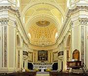
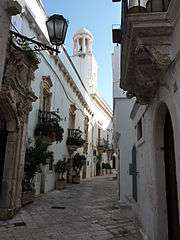
Locorotondo's heritage includes the Mother Church of "St. George the Martyr", built between 1769 and 1821 and including 14th century basreliefs; the church of "San Rocco", the Romanesque church of "Our Lady of Greece". The beauty of the historic centre is also represented by a labyrinth of white alleys, jealously guarded by their inhabitants. The houses are topped with unusual pitched roofs called "cummerse", a feature typical of the historical centre of Locorotondo.
The Locorotondo countryside is an example of an area of dispersed settlements (jazzelere) and has an abundance of trulli dwellings which were built around a communal area called "jazzile". This settlement pattern is due in large part to emphyteutic leases, particularly in the 19th century for the development of vineyards.[2]
Locorotondo DOC
The commune of Locorotondo produces a white Denominazione di origine controllata (DOC) Italian wine that can be made in a still or sparkling Spumante style. The DOC includes 1,650 hectares (4,000 acres) of vineyards. All grapes destined for DOC wine production must be harvested to a yield no greater than 13 tonnes/ha. The wine is made predominantly (50-65%) from Verdeca and Bianco d'Alessano which can make up 45-50% of the blend. Additional grapes are permitted up to a maximum of 5% including Bombino bianco, Fiano and Malvasia Toscana. The finished wine must attain a minimum alcohol level of 11% in order to be labelled with the Locorotondo DOC designation.[3]
Twin towns
 Trzebnica, Poland
References
- ↑ (Italian) "The Most Beautiful Villages of Italy"
- ↑ Anthony H Galt, Far from the Church Bells (CUP, 1991)
- ↑ P. Saunders Wine Label Language pg 174 Firefly Books 2004 ISBN 1-55297-720-X
External links
- (Italian) Comune di Locorotondo
- Cantina Sociale del Locorotondo (multilingual)
- (Italian) The Most Beautiful Villages of Italy

