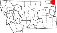
List of lakes in Sheridan County, Montana
This list is incomplete; you can help by expanding it.
There are at least 28 named lakes and reservoirs in Sheridan County, Montana.
Lakes
- Brightsmen Lake, 48°58′49″N 104°23′43″W / 48.98028°N 104.39528°W, el. 2,257 feet (688 m)[1]
- Brush Lake, 48°35′55″N 104°06′35″W / 48.59861°N 104.10972°W, el. 1,959 feet (597 m)[2]
- Capeneys Lake, 48°28′20″N 104°19′18″W / 48.47222°N 104.32167°W, el. 1,939 feet (591 m)[3]
- Clear Lake, 48°39′12″N 104°08′44″W / 48.65333°N 104.14556°W, el. 2,018 feet (615 m)[4]
- Comers Lake, 48°53′45″N 104°15′18″W / 48.89583°N 104.25500°W, el. 2,287 feet (697 m)[5]
- Dominek Lake, 48°43′33″N 104°05′33″W / 48.72583°N 104.09250°W, el. 2,041 feet (622 m)[6]
- Flat Lake, 48°54′43″N 104°05′12″W / 48.91194°N 104.08667°W, el. 2,096 feet (639 m)[7]
- Gaulke Lake, 48°54′01″N 104°03′08″W / 48.90028°N 104.05222°W, el. 2,073 feet (632 m)[8]
- Goose Lake, 48°48′47″N 104°04′17″W / 48.81306°N 104.07139°W, el. 2,051 feet (625 m)[9]
- Horseshoe Lake, 48°35′42″N 104°02′43″W / 48.59500°N 104.04528°W, el. 1,965 feet (599 m)[10]
- Johnson Lake, 48°59′11″N 104°22′27″W / 48.98639°N 104.37417°W, el. 2,228 feet (679 m)[11]
- Katy Lake, 48°31′30″N 104°12′23″W / 48.52500°N 104.20639°W, el. 1,952 feet (595 m)[12]
- Larson Slough, 48°57′25″N 104°11′28″W / 48.95694°N 104.19111°W, el. 2,175 feet (663 m)[13]
- Lochin Slough, 48°55′18″N 104°34′54″W / 48.92167°N 104.58167°W, el. 2,356 feet (718 m)[14]
- Lone Tree Lake, 48°56′28″N 104°13′39″W / 48.94111°N 104.22750°W, el. 2,146 feet (654 m)[15]
- Long Lake, 48°33′35″N 104°09′13″W / 48.55972°N 104.15361°W, el. 1,952 feet (595 m)[16]
- Mallard Pond, 48°34′21″N 104°08′27″W / 48.57250°N 104.14083°W, el. 1,952 feet (595 m)[17]
- Mattson Slough, 48°56′21″N 104°34′56″W / 48.93917°N 104.58222°W, el. 2,395 feet (730 m)[18]
- North Lake, 48°53′02″N 104°04′01″W / 48.88389°N 104.06694°W, el. 2,080 feet (630 m)[19]
- Park Lake, 48°53′57″N 104°18′22″W / 48.89917°N 104.30611°W, el. 2,316 feet (706 m)[20]
- Salt Lake, 48°59′48″N 104°18′01″W / 48.99667°N 104.30028°W, el. 2,165 feet (660 m)[21]
- Syme Slough, 48°54′28″N 104°35′55″W / 48.90778°N 104.59861°W, el. 2,326 feet (709 m)[22]
- Tadpole Lake, 48°48′03″N 104°10′19″W / 48.80083°N 104.17194°W, el. 2,126 feet (648 m)[23]
- Widgeon Slough, 48°57′53″N 104°14′49″W / 48.96472°N 104.24694°W, el. 2,155 feet (657 m)[24]
Reservoirs
- Boxelder Lake, 48°47′12″N 104°33′15″W / 48.78667°N 104.55417°W, el. 2,093 feet (638 m)[25]
- Homestead Lake, 48°22′11″N 104°35′04″W / 48.36972°N 104.58444°W, el. 1,929 feet (588 m)[26]
- Homestead Lake, 48°24′30″N 104°34′14″W / 48.40833°N 104.57056°W, el. 1,926 feet (587 m)[27]
- Medicine Lake, 48°28′37″N 104°30′34″W / 48.47694°N 104.50944°W, el. 1,936 feet (590 m)[28]
See also
Notes
- ↑ "Brightsmen Lake". Geographic Names Information System. United States Geological Survey.
- ↑ "Brush Lake". Geographic Names Information System. United States Geological Survey.
- ↑ "Capeneys Lake". Geographic Names Information System. United States Geological Survey.
- ↑ "Clear Lake". Geographic Names Information System. United States Geological Survey.
- ↑ "Comers Lake". Geographic Names Information System. United States Geological Survey.
- ↑ "Dominek Lake". Geographic Names Information System. United States Geological Survey.
- ↑ "Flat Lake". Geographic Names Information System. United States Geological Survey.
- ↑ "Gaulke Lake". Geographic Names Information System. United States Geological Survey.
- ↑ "Goose Lake". Geographic Names Information System. United States Geological Survey.
- ↑ "Horseshoe Lake". Geographic Names Information System. United States Geological Survey.
- ↑ "Johnson Lake". Geographic Names Information System. United States Geological Survey.
- ↑ "Katy Lake". Geographic Names Information System. United States Geological Survey.
- ↑ "Larson Slough". Geographic Names Information System. United States Geological Survey.
- ↑ "Lochin Slough". Geographic Names Information System. United States Geological Survey.
- ↑ "Lone Tree Lake". Geographic Names Information System. United States Geological Survey.
- ↑ "Long Lake". Geographic Names Information System. United States Geological Survey.
- ↑ "Mallard Pond". Geographic Names Information System. United States Geological Survey.
- ↑ "Mattson Slough". Geographic Names Information System. United States Geological Survey.
- ↑ "North Lake". Geographic Names Information System. United States Geological Survey.
- ↑ "Park Lake". Geographic Names Information System. United States Geological Survey.
- ↑ "Salt Lake". Geographic Names Information System. United States Geological Survey.
- ↑ "Syme Slough". Geographic Names Information System. United States Geological Survey.
- ↑ "Tadpole Lake". Geographic Names Information System. United States Geological Survey.
- ↑ "Widgeon Slough". Geographic Names Information System. United States Geological Survey.
- ↑ "Boxelder Lake". Geographic Names Information System. United States Geological Survey.
- ↑ "Homestead Lake". Geographic Names Information System. United States Geological Survey.
- ↑ "Homestead Lake". Geographic Names Information System. United States Geological Survey.
- ↑ "Medicine Lake". Geographic Names Information System. United States Geological Survey.
This article is issued from Wikipedia - version of the 11/7/2016. The text is available under the Creative Commons Attribution/Share Alike but additional terms may apply for the media files.
