Øyeren
| Øyeren | |
|---|---|
 | |
 Map of Øyeren and surrounds | |
| Location | Akershus and Østfold counties, Norway |
| Coordinates | 59°51′26″N 11°09′48″E / 59.85722°N 11.16333°E / 59.85722; 11.16333Coordinates: 59°51′26″N 11°09′48″E / 59.85722°N 11.16333°E / 59.85722; 11.16333 |
| Type | Natural lake |
| Basin countries | Norway |
| Surface area | 84.74 km² |
| Max. depth | 71 m |
| Shore length1 | 165.47 km |
| Surface elevation | 101 m |
| References | NVE |
| 1 Shore length is not a well-defined measure. | |
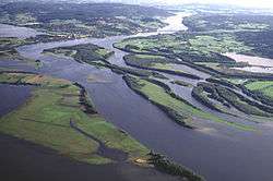
Øyeren is a lake in the Glomma River watershed, southeast of Lillestrøm. It is located within the municipalities of Enebakk, Skedsmo, Fet and Rælingen in Akershus county and Spydeberg and Trøgstad municipalities in Østfold county.
Lake Øyeren is the ninth largest lake by area in Norway with a surface area of 84.7 km². It is 101 meters above sea level and 71 meters deep.
The name
The name of the lake (Norse Øyir) is derived from øy f 'island; flat and fertil land along a waterside'.
Nordre Øyeren nature preserve
An area which includes parts of the northern ("nordre") end of the lake is an established nature preserve, listed as a Ramsar site.
External links
- Øyeren information center (Norwegian )
- Nordre Øyeren natur preserve (Norwegian )
- Ramsar Sites Information on Nordre Øyeren (English )
This article is issued from Wikipedia - version of the 12/27/2015. The text is available under the Creative Commons Attribution/Share Alike but additional terms may apply for the media files.